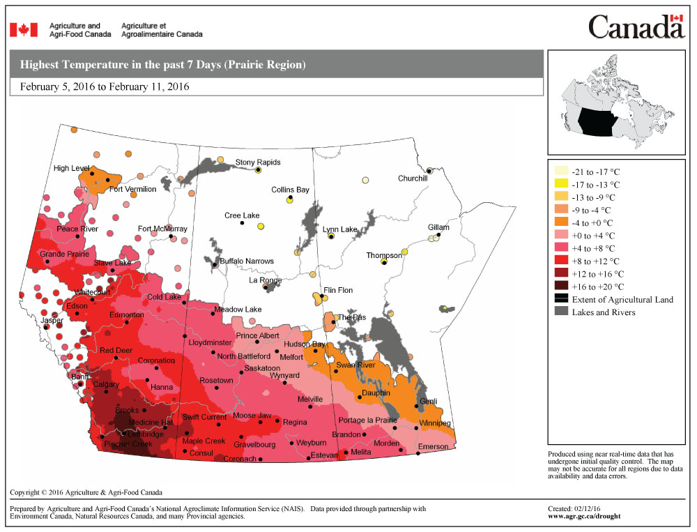
It doesn’t look like the weather pattern we’ve been in for the last month or so is going to change any time soon. Here is the big picture of what is going on. To our west, there has been a fairly persistent area of low pressure off the coast that has been drifting north and south as smaller lows get pulled into it. Over western regions there is a fairly persistent ridge of high pressure that has been bringing mild temperatures up and down the West Coast and inland into Alberta. To our east we have another area of low pressure that has been quite dominant over northeastern regions of Canada.
Read Also

Forecasting spring 2026 weather on the Prairies
What weather can farmers expect across Manitoba, Alberta and Saskatchewan as they head into seeding? Plus: a lesson on what makes the seasons turn
Now picture the general airflow going under the western low, then rising up over the western ridge, and then diving back down under the eastern low. This puts us under a predominantly northwestern flow. Areas of energy, or smaller lows, break off the big Pacific low, then either kick off to our south or get caught up in the northwesterly flow. Mild air works in ahead of these lows, then colder air pours in behind the lows.
This forecast period will begin with a cool area of high pressure that will quickly be replaced by an area of low pressure sliding in from the west. We’ll start seeing southerly winds pick up ahead of the low on Wednesday, and clouds along with flurries or even a few showers moving in by Friday. Temperatures look to warm up into the low single digits by Friday with clouds, flurries and mild temperatures looking like they will stick around for at least the first half of the weekend.
Once this low pulls off to the east, another arctic high will slide southward. This should bring a return to sunshine along with cooler temperatures for most of next week, with highs expected to be in the -10 to -14 C range and overnight lows around -22 C.
Usual temperature range for this period: Highs, -18 to -4 C; lows, -30 to -11 C.