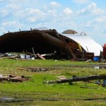
The Raynor’s farmland was completely dishevelled and a number of out buildings were destroyed.

Tornado among several storm events in the southwest

Two rural properties took the brunt of Manitoba's most recent violent weather episode

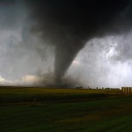
Displaced bales, crushed crops and chunks of metal scatter fields in the southwest as the area recovers from one of Manitoba’s largest tornadoes in recent years. A low-pressure system that moved in from Montana sparked the extreme weather, which also doused the Virden area with nearly 75 mm of rain. Quarter-sized hail was also reported

Instability and vorticity: The ingredients that make a tornado

Instability and vorticity: The ingredients that make a tornado

Since they can’t get inside to measure, scientists aren’t completely sure how funnel clouds and tornadoes form

So far this month weather conditions have been fairly good for thunderstorms to develop with plenty of warm, humid air around. This week, we’ll continue our look at severe thunderstorms, and specifically, the most deadly part — tornadoes. What are tornadoes and how do they form? A classic definition of a tornado is a violently


General weather pattern remains the same

Issued: Monday, July 20, 2015 – Covering: July 22 – July 29, 2015

The overall weather pattern doesn’t look like it will change much during this forecast period. We’re currently in a pattern that has a moderate ridge of high pressure over central North America, with this high extending northwards to about the central Prairies. To our east and west are troughs of low pressure. The western trough

Temporary cool-down next week?

Issued: Monday, July 13, 2015 – Covering: July 15 – July 22, 2015

Last week’s forecast didn’t play out exactly as the weather models predicted, but that was not unexpected with the slack flow across our region. For those living in the south, the smoke cleared out for the most part, a little earlier than expected, and a slow-moving upper low allowed very warm and humid air to


A slight chance of thunderstorms

Issued: Monday, July 6, 2015 – Covering: July 8 – July 15, 2015

Last week’s forecast played out pretty much as expected, with an area of low pressure pushing through a cold front, which brought a fairly wide outbreak of thunderstorms on Saturday and Sunday. Cooler temperatures moved in to start this week, which brought some relief from the warm and humid conditions. A typical slack and muddled

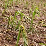
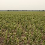
This cornfield north of Miami was one of many pulverized by hail June 27. More fields received hail July 4.

Another week, another hailstorm

MASC is busy processing more hail claims, severe weather damage

Thunderstorms damaged more Manitoba crops July 4 — one week after a vicious hailstorm injured or destroyed crops from Roseisle to Winkler, running roughly parallel to the Pembina Escarpment. As of July 6 the Manitoba Agricultural Services Corporation (MASC) had received 164 hail claims on insured crops, said David Koroscil, MASC’s manager for insurance projects


A severe thunderstorm the afternoon of Saturday June 27 hit near the Roseisle area west of Carman. Many fields in the area were destroyed or damaged by hail including this soybean field at the Junction of  PR 240 and 245.

Manitoba Crop Report and Crop Weather report: Issue 9

Conditions as of June 29

Weekly Provincial Summary Severe weather systems containing strong winds, heavy rains and hail passed through isolated areas in several Regions of Manitoba. Damage to crops from hail and strong winds range from light to severe with assessments continuing over the next several days. However, overall good growing conditions continue to advance crops, as well as allowing


Mix of sun and scattered thundershowers

Issued: Monday, June 22, 2015 – Covering: June 24 – July 1, 2015

This forecast period is starting off much like the last one. The general flow of the atmosphere is fairly zonal, which means a strong west-to-east flow. Sometimes it’s coming a little out of the northwest, which results in slightly cooler conditions, and sometimes it veers a little southwest, which means warmer weather. The trouble is,

Unsettled weather and a look at precipitation across the Prairies

Issued: Monday, June 8, 2015 – Covering: June 10 – June 17, 2015

As we slowly transition into summer, forecasting the weather usually gets easier, but so far not this year. The overall pattern for the next week to 10 days looks like it will continue to be active, with two main low-pressure tracks setting up. The first is to our south, across the northern states; the second