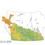
This map shows the total precipitation across the Prairies so far this growing season compared to the long-term average. Most of the Prairies have seen average to well-above-average amounts, with the wettest areas located in a northwest swath from Brandon to just west of Saskatoon.

Unsettled weekend but heat building in next week

Issued: Monday, July 21, 2014 · Covering: July 23 – July 30, 2014

The first half of last week’s forecast was pretty much spot on, as the forecasted trough of low pressure moved through our region last weekend bringing with it a mix of sun, clouds, warm temperatures and a few showers and thundershowers. For the first part of this forecast period high pressure looks to dominate, bringing

Cooler and wetter in the forecast

So far the weather models have been pretty good this summer. The only real problem, as usual, is with the timing of the different systems. For this forecast period it looks as if the weather pattern might be trying to undergo a bit of a change to cooler and wetter conditions. To start off this


Short heat wave to come to an end

As forecasted last week, a ridge of high pressure developed over our region during the first half of this week, bringing sunny skies and warm summer temperatures. This ridge of high pressure looks like it will begin to break down starting on Thursday, and we’ll begin a slow transition into cool temperatures. After a really

Monitoring thunderstorm movement

Storms can strengthen or weaken as they move. Use online and visual tools to track their movements


In the last issue we continued our look at thunderstorms and severe summer weather by examining the direction thunderstorms move. In this issue we’ll learn how to determine the strength of a thunderstorm. Pretty much any storm can produce severe weather. If there are severe thunderstorm watches or warnings out, and you see a storm


Hit-and-miss long weekend

Last week’s forecast turned out to be fairly accurate; the only thing that was off was the amount of warming we saw on Sunday and Monday. The first half of this forecast period will be controlled by a large area of low pressure that will develop to our west. While the weather models have been

Thunderstorms And Hail

With plenty of severe weather occurring all across the Canadian Prairies this summer, I thought we should go back and take a look at some of the aspects of severe summer weather. The first thing that pops into my mind when it comes to severe summer weather is thunderstorms.Thunderstorms can bring several types of destructive


Forecast – for Jun. 23, 2011

Well, it felt a little more summerlike this past week and some areas were able to dry out, but other areas got hammered once again with heavy rains coming in the form of thunderstorms. In what seems to be a pattern this spring, we are once again starting this forecast period with a strong and

Forecast – for Jun. 9, 2011

It seems we are stuck with a broken record weatherwise. The current unsettled pattern looks to continue for at least this forecast period. The only good news is that we are slowly making our way into summer, which means no matter what, our temperatures will continue to slowly warm up! This week once again looks


Forecast – for Jun. 2, 2011

The weather models have been having a fair bit of trouble lately and this looks to continue into this forecast period. Last week the models predicted a strong low forming to our west over the weekend, then moving to the northeast. This low did form, but farther south, and it moved in early, bringing the

Forecast – for May. 26, 2011

Last week’s forecast started off exactly as the models predicted, but by the time the weekend rolled around things got a little off track. The weather models had predicted the large area of low pressure that affected us over the weekend, but they originally kept most of the clouds and rain to our south. Unfortunately,