So far the weather models have been pretty good this summer. The only real problem, as usual, is with the timing of the different systems. For this forecast period it looks as if the weather pattern might be trying to undergo a bit of a change to cooler and wetter conditions.
To start off this forecast period, it looks like high pressure will once again be in place, bringing more sun than clouds, along with high temperatures in the upper 20s to low 30s. A weak area of low pressure could bring the odd shower on Wednesday, but by late Friday or early Saturday a much stronger system is expected to move through. This system will likely bring a good chance of thunderstorms and showers and depending on the timing of the system, some of these storms could be severe.
Read Also

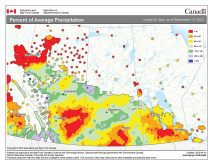
June brings drought relief to western Prairies
Farmers on the Canadian Prairies saw more rain in June than they did earlier in the 2025 growing season
This system looks like it will be followed by a second area of low pressure early next week. The weather models have been having a heck of a time with this second feature, so confidence is not that high. Should this upper low move through as forecasted on Sunday and/or Monday, then we could expect a mix of sun and clouds along with a few showers and much cooler temperatures. Highs on these days will likely only be in the low 20s.
High pressure looks as if it will build back in for the middle of next week, bringing with it sunshine and warming temperatures. We will likely see highs in the mid-20s on Tuesday, warming to the upper 20s by Wednesday or Thursday.
Usual temperature range for this period: Highs, 21 to 31 C; Lows, 9 to 16 C.