There was a little discrepancy in last week’s weather outlook. We had more clouds and showers early on, before the predicted milder air finally moved in over the long weekend. The strong area of low pressure predicted to begin affecting our region May 18 to 20 is still on track as I’m writing this, but the models now show the main low hanging back in the southwestern United States, with bits of energy breaking off and moving our way during the week — and this is where this issue’s outlook begins.
Read Also
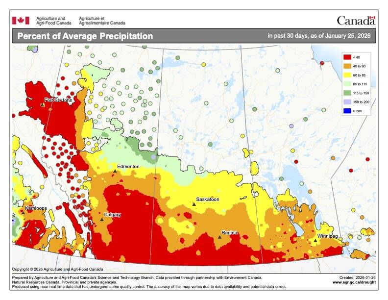
What’s the weather for last half of winter 2025-2026?
A last look at 2025 temperature and precipitation on the Prairies, plus what weather forecasters expect through to spring 2026.
The low to our southwest will eject pieces of energy to the northeast from May 20 to 22. This will bring our region a mix of sun and clouds along with the chance of showers and thundershowers each day. Expect daytime highs to warm into the mid- to possibly upper 20s, given enough sunshine, with overnight lows only dropping to around the 10 C mark.
By Friday and into the start of the weekend, the main area of low pressure is forecast to track northward into Saskatchewan or western Manitoba before weakening and moving off to the east on Sunday. Should the western track materialize, we would stay on the warm side of the low on Saturday before cooling back down into the upper teens to around the 20 C mark on Sunday as the low moves off to our east. Expect unsettled conditions with the chance of showers or thundershowers continuing — and more significant rainfall, should the low track farther east.
For the period of May 25 to 27, the weather models show seasonable temperatures, with daytime highs forecast to be in the upper teens to low 20s and overnight lows in the 6 to 10 C range. With the milder temperatures and a few weak systems around, the odd shower or thundershower can’t be ruled out on any given day.
Usual temperature range for this period: Highs, 12 to 26 C; lows, 1 to 10 C.