Highlights
- Several storm systems are setting up across the Prairies with potential for rain, freezing rain and snow
- Arctic air is expected to follow the lows with cool temperatures over the weekend
- Milder temperatures are expected to return early next week
Prairie forecast overview
I would love to say that spring weather is ready to settle in for good, but unfortunately that would not be accurate. The pattern of the four to six weeks looks set to continue — meaning more cold than warmth and several storm systems capable of bringing anything from rain to freezing rain to snow.
Read Also
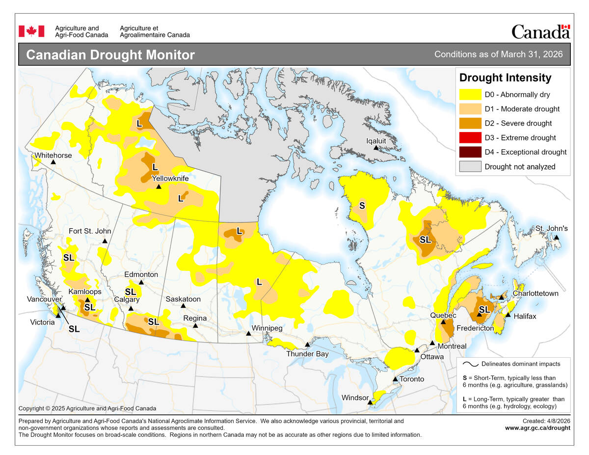
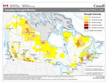
Canadian drought conditions improve in March
Normal to above normal precipitation in March helped moisture conditions improve across much of Canada, according to the latest Canadian Drought Monitor data from Agriculture and Agri-Food Canada
This forecast period starts with a fairly complex. An area of low pressure is pushing across central Alberta, bringing light snow to that region. This system will track into central Saskatchewan, producing a swath of snow from around Saskatoon northward. It will then weaken as it moves into northern Manitoba on Thursday just as a second area of low pressure develops over the northwestern U.S. and begins to push eastward.
- More weather coverage: Canadian drought conditions improve in March
This second low is expected to bring some accumulating snow to southern Alberta late Wednesday into Thursday as it organizes south of the border. Confidence in the exact track remains somewhat low, even at this short range, although recent model trends have shifted slightly southward.
This system will need to be watched closely, as it has the potential to bring a wintry mix of precipitation to southern Saskatchewan and Manitoba, beginning Thursday in Saskatchewan and Friday in Manitoba.
Once this system exits to the east, cold Arctic air will remain in place over the weekend, keeping daytime highs well below seasonal averages. The models then suggest a return of milder air by Monday, with the warmest temperatures expected across the western Prairies.
Alberta
As mentioned, this is a complicated start to the forecast period, with two related systems affecting the province. A low pushing in from British Columbia will bring light snow and cooler temperatures to central and northern Alberta on Wednesday before moving into central Saskatchewan on Thursday.
At the same time, a second piece of energy is forecast to drop southward into Montana. This brings potential for accumulating snow to parts of southern Alberta late Wednesday as colder air feeds into the system.
Both systems should exit the region by Friday, allowing skies to clear as weak Arctic high pressure settles in. Expect daytime highs to remain in the low single digits on Friday and Saturday before milder air begins to return on Sunday.
Weak upper-level ridging is forecast to develop over British Columbia through the weekend and into early next week. This should support a gradual warm-up, with daytime highs reaching the mid-teens by Tuesday.
Saskatchewan and Manitoba
Central Saskatchewan will begin to feel the effects of the Alberta low on Thursday as it tracks eastward. Snow is expected to develop overnight Wednesday and continue through much of Thursday before the system weakens and moves into northern Manitoba. Current indications suggest snowfall totals of 10 to 15 cm along and just north of the system’s track.
Attention then shifts to a developing low over the northwestern U.S.
Models continue to struggle with both timing and track, which could significantly impact the forecast. The latest guidance suggests the low will dip south from Montana toward Colorado before lifting quickly northeast toward Lake Superior by late Friday or early Saturday. Snow is expected to develop over southern Saskatchewan on Thursday as warm air overruns cold Arctic air entrenched across the northern Prairies.
- More from Daniel Bezte: Alberta saw best and worst of winter this year
As the main low lifts northeast, a secondary area of precipitation is expected to develop over southeastern Saskatchewan and western Manitoba. This will likely fall mainly as snow, although some freezing rain cannot be ruled out, particularly over southeastern Manitoba.
The system should move through relatively quickly, exiting by late Friday or early Saturday morning and leaving behind a return to cold Arctic air. Daytime highs on Friday and Saturday will struggle to reach the freezing mark.
Milder air is expected to push northward again by Sunday across Saskatchewan and by Monday across Manitoba, with daytime highs climbing back into the low teens, especially over Saskatchewan.