Manitoba farmers had a cold, dry slog of it this winter, if we delve into the data as the season ends.
We’ll start at the end, and look at the March numbers.
Read Also
Forecasters flag ‘eye-popping’ El Nino with major implications for global crop production
Forecasters are flagging a potential record-strength El Nino that could reshape global crop production and trade flows heading into 2026-27 marketing year.
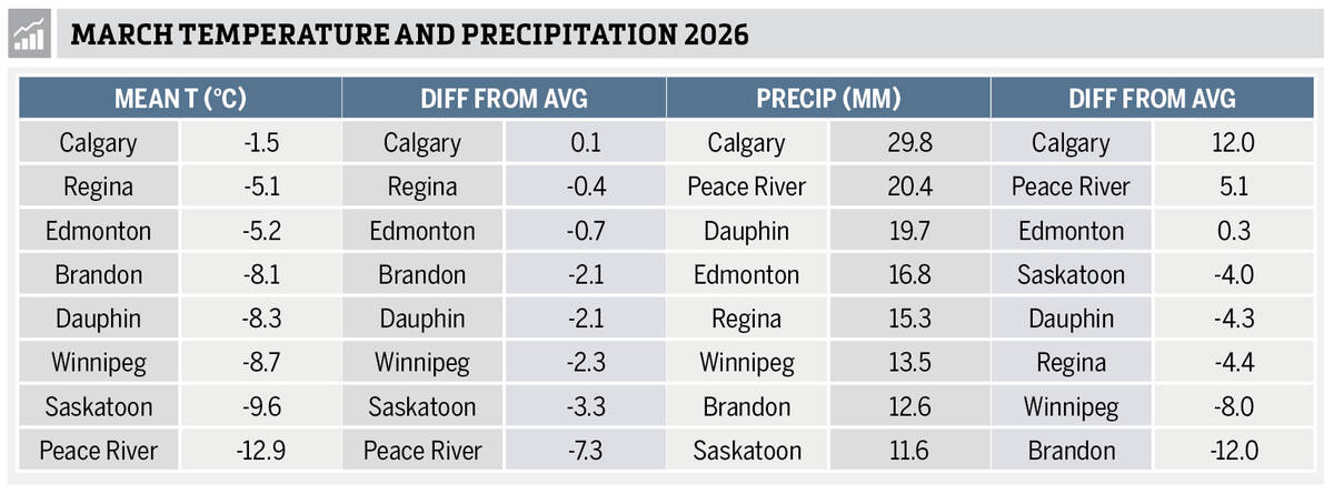
The table ranks the stations from warmest to coldest and then from warmest to coldest compared to their average.
Cold treatment
If you thought March was a cold month, then you were right.
Central Saskatchewan and southern Manitoba were the coldest spots, with mean monthly temperatures running between 2 C and 3 C below average.
Regina and Edmonton saw their mean March temperature coming in slightly below average.
Most of the main reporting stations across the Prairies showed colder-than-average temperatures, with the notable exception of Calgary.
The west was warmest, with Calgary seeing the highest actual mean temperature for the month, followed by Edmonton.
Interestingly, the coldest reading was also in Alberta with Peace River coming in at a very chilly -12.9 C.
Winter snow
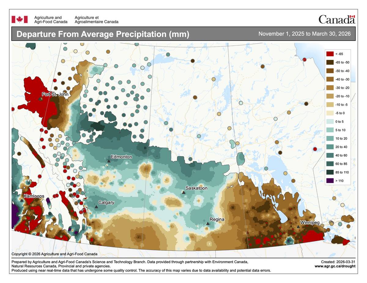
When it came to precipitation, Manitoba and Saskatchewan didn’t have good news to report for farmers hoping to recharge soils heading into seeding. Precipitation in these provinces ranged from slightly below to well-below average, although the province of Manitoba recently announced that flood risk had been ramped up for parts of western Manitoba and the Interlake, and the snow pack was part of the reason.
Saskatoon was the driest location with only 11.6 mm, and Brandon was the driest when compared to average, coming in at 12 mm below the long-term average.
Alberta was the wet spot in March with all three locations reporting above-average amounts. Calgary saw the most moisture, with about 30 mm of precipitation, or 12 mm above average.
Summing up March, it was cooler than average in most of the Prairies and conditions were moist in Alberta and drier through Saskatchewan and Manitoba.
The full winter picture
Overall there seems to be a sense that this winter was a long one, probably because it held on harder than usual in March. But was it a particularly harsh winter? There the numbers aren’t so clear.
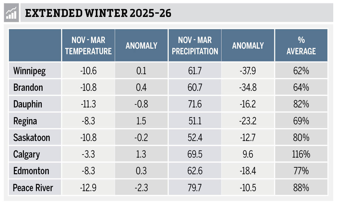
The accompanying table shows average temperature and how much that differed from normal — or what’s known as the “anomaly.” It also shows total precipitation, the anomaly and per cent of average precipitation.
For the November to March time frame, we can see Manitoba and Saskatchewan’s mean temperatures mainly occurred in a narrow band within half a degree of -11 C. Calgary was the warm spot coming in at -3.3 C, while Peace River was the cold spot at -12.9 C.
If we compare these to the average, it becomes a bit more of mixed bag. Dauphin and Saskatoon came in slightly below average. Winnipeg, Brandon, and Edmonton came in slightly above average, while Calgary and Regina came in solidly above average.
Precipitation this past winter, at least according to the data from these stations, was mostly below average. All the stations but one reported below-average values with amounts ranging from 62 per cent of average in Winnipeg to 88 per cent in Peace River. Calgary was again the exception, coming in at 116 per cent of average.
The skinny on winter 2025-26
So overall, the winter of 2025-26 saw near- to above-average temperatures, except for the Peace River region of Alberta which saw below-average temperatures. Precipitation was generally below average but not severely, with only the Calgary region reporting slightly above average amounts.
We will look at the longer range forecasts for May to August later in April.