Due to the timing of deadlines this holiday season, I cannot provide the usual weather forecast.
Instead, I thought we would have a little fun and take a brief look at the latest long-range outlooks for 2023. I will dig deeper into this topic in January and examine some of the factors that may drive our weather patterns over the next 12 months, or at least as far ahead as the different models go.
Let’s start with the two almanacs. The Old Farmer’s Almanac is calling for a brutally cold start to 2023, with temperatures switching to above average in the spring and remaining above average right through the year. It looks to be a wet year with nearly every month showing above-average precipitation.
Read Also

VIDEO: Here’s Manitoba’s 2026 spring storm forecast
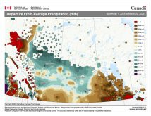
Weather models are calling for above-average precipitation in southern Manitoba, with at least two more Alberta clippers possible.
The Canadian Farmers’ Almanac is calling for average temperatures and above-average snowfall for the remainder of the winter. Spring is predicted to see average temperatures and near- to above-average rainfall. It is calling for summer to be warm and dry, followed by a cool wet fall and early winter.
Moving to the computer models, NOAA is calling for a cooler-than-average start to the year with above-average precipitation. Temperatures will moderate toward average values by spring, with near-average precipitation.
Temperatures will continue to moderate, moving toward slightly above-average values in the summer and early fall. Precipitation looks to be average to slightly below average during the summer and fall.
[RELATED] Manitoba’s spring storms, my top story of 2022
The CFS model is calling for a warm start to 2023, but then cooler-than-average temperatures from February to April, with the core of the cool weather centered over Alberta. Precipitation during this period is forecasted to be near to slightly above average.
The rest of the year, at least up to next September, is forecasted to see above-average temperatures and near- to above-average amounts of precipitation.
Finally, the CanSIPS model is forecasting near- to slightly above-average temperatures in every month from January to September, except for March, which shows below-average values. Precipitation is forecasted to be near to above average over the remainder of the winter and into early spring, and then transition to near- to below-average amounts later in spring and right through to the fall.
Usually, I would end with my long-term outlook, but to tell the truth, I do not have a clue right now. When I do my deeper dive into this topic in January, I will have some of my own conclusions.
Until then, I hope you have a wonderful holiday season!