

I have a few thing to cover in this article. First of all, where did all the snow go from the big blizzard that hit western Manitoba? I was lucky enough to head out with my school for a couple of days of skiing at Asessippi last week and I was scratching my head trying to figure out where all the snow was. Don’t get me wrong; there were some very impressive drifts, but with all the high winds, most of the fields were blown clear of any new snow. The only places that had big deep accumulations of new snow were the sheltered areas. My son also travelled to Brandon this week and reported similar conditions. I would love to hear from anyone who can help sort this out, considering snowfall amounts of up to 40 cm were reported in some areas. How much new snow do you think actually fell in your area?
Read Also

Forecasting spring 2026 weather on the Prairies
What weather can farmers expect across Manitoba, Alberta and Saskatchewan as they head into seeding? Plus: a lesson on what makes the seasons turn
On to a more global view. February’s global temperatures were released last week and the numbers were a bit surprising. Despite a five-month-long La Niña event, which usually helps to cool the planet a little bit, February 2017 continued a nearly two-year-long trend of extremely warm global temperatures. According to both NOAA and NASA, this February was the second- warmest February on record, only coming in second to last February. This February ranked as the fourth warmest month, compared to average, by NASA and was the seventh-warmest month, according to NOAA. For those of you who don’t trust either of those two databases, the University of Alabama in Huntsville — which monitors global satellite-measured temperatures for the lowest eight km of the atmosphere — reported this February was the fourth-warmest in its 39-year database.
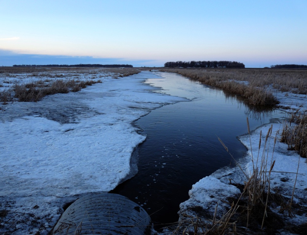
Now, back to our region and our first look at potential spring flooding. All I can say is, I wouldn’t want to be trying to figure out what is going to happen this spring. I am not a hydrologist, though I did take hydrology when I was in university, so I think I have a basic understanding of what is going on, and holy cow, is this spring becoming complicated!
Insulation against frost
To start off, we had a very wet fall across eastern and western regions, with the south-central regions seeing average moisture levels. These wet conditions led to soil moisture levels in the top 120 cm to run as high as 95 per cent of capacity over a large area — the only “dry” region being found in the southern Interlake, where available moisture was at 65 per cent of capacity. So far not a good start, but as most of you know, it’s the weather during the winter and spring that really impacts spring flooding. Now, let’s add to this wet beginning the warm start to winter, which prevented deep frost from forming. Once it did get cold, we received a fair bit of snow that helped to create a good insulating layer. This resulted in most regions having a lower-than-average frost depth this winter, which can be a good thing when it comes to spring flooding as the ground can more easily absorb some of the snow melt.
So far so good; maybe the two things can help balance each other out a little bit. Now we move on to the up-and-down winter that saw several significant snowmelts occur, followed by significant freezes. These freeze-and-thaw cycles have, in my opinion, created a real mess. On the positive side, a fair bit of the snowmelt has occurred. The question is, just how much of this has made its way into the river systems and how much is sitting around as ice? That’s my next point. There is a lot of ice around. All the melting and freezing has created conditions I personally have never seen. The remaining snowpack is nearly solid ice. This means that while there doesn’t look like there is a lot of snow around, there is still a fair bit of water in the ice waiting to melt and run off. Also, with the top layer of soil now saturated — and, with the cold weather, now frozen — any meltwater will quickly run off.
The final piece to the spring flooding puzzle is the weather between now and the end of April. All it takes is one wet storm, or a series of fairly wet storms, to make things go from good to bad. The current mid-range weather models show a fairly active pattern right through to at least the first week of April. Does this mean we’ll see a lot of rain or snow? Not necessarily, but the odds are pretty good we will see some significant precipitation during this period. There will be storm systems around; the question is whether all of the pieces will come together or not — and if they do, will the storm hit us or just miss?
Overall, I would say, all things considered, our spring flooding situation is not looking that good. The government should be coming out with an updated forecast soon and I wouldn’t be surprised to see that most rivers across our region will be upgraded to a high risk of moderate to major spring flooding. Let’s cross our fingers and hope the weather models are wrong and we see near-perfect weather over the next month.


