

Let’s look at a couple more factors that might impact how our winter will play out — early snowpack development across Siberia and a warmer-than-average far northern Pacific Ocean.
When snow accumulates early across Siberia in September or October, it dramatically increases the surface albedo, reflecting more sunlight back into space.
The result is rapid cooling of the lower atmosphere, which strengthens a dome of cold, dense air over the Eurasian continent known as the Siberian High. This high-pressure area intensifies the temperature contrast between the frigid north and the still-mild mid-latitudes, sharpening what is know as the baroclinic zone where large-scale atmospheric waves form and propagate.
Read Also

Forecasting spring 2026 weather on the Prairies
What weather can farmers expect across Manitoba, Alberta and Saskatchewan as they head into seeding? Plus: a lesson on what makes the seasons turn
The movement of energy through the atmosphere impacts the generation of these planetary (also known as Rossby) waves. These are the massive undulations that dominate the jet stream, creating what we call upper-level ridges and troughs. These waves act as a communication system between the troposphere (the lower atmosphere where weather occurs) and the stratosphere above.
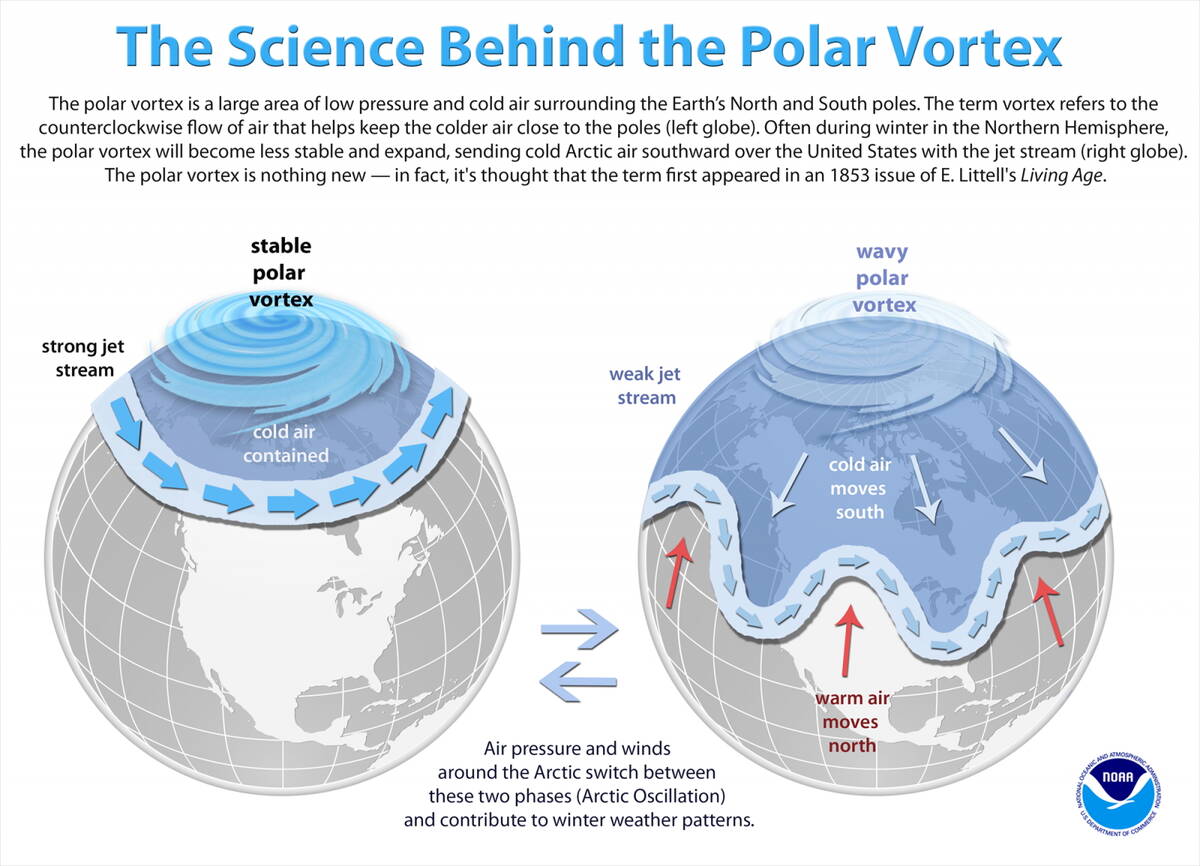
As theses waves amplify over Eurasia, they can propagate upward into the stratosphere in late autumn. There, they interact with the stratospheric polar vortex, a vast, fast-spinning region of cold air encircling the Arctic at high altitudes that has been making the news almost every time we get a severe outbreak of cold air. When these upward-moving waves become strong, they deposit momentum and heat into the stratosphere, slowing and displacing the vortex. The result is a weaker, warmer, and often off-center polar vortex.
Polar vortex
A disrupted vortex often leads to higher surface pressures over the polar region and weaker westerly winds at mid-latitudes. This state corresponds to the negative phase of the Arctic Oscillation (AO) and the North Atlantic Oscillation (NAO) — atmospheric patterns that profoundly shape winter weather across the Northern Hemisphere.
When the AO turns negative, the jet stream becomes wavier and shifts southward. Instead of locking cold air in the Arctic, it allows frigid air masses to plunge southward. In North America, this typically brings colder and often snowier conditions to central and eastern regions, while the west may experience milder and drier weather.
The timing of these events follows a rough sequence: early-season snow in October, wave amplification in November, stratospheric weakening in December, and surface impacts by January or February. Thus, what happens over Siberia in autumn can influence the probability of cold snaps months later across North America.
Just like with El Niño or La Niña this relationship is probabilistic, not deterministic — it can increase the chance of a colder winter, in other words, but does not guarantee it.
Many other climate drivers can either amplify, neutralize, or even override the snow signal. So far this year, Siberian snow cover advanced early but slowed in recent weeks, so exactly how much of a factor it will be is still uncertain.
Despite these uncertainties, the Siberian snow connection offers a fascinating example of how interconnected Earth’s climate system truly is. A few weeks of early snowfall in central Asia can set in motion atmospheric waves that travel across continents and through layers of the atmosphere, influencing winter patterns half a world away.
This is one region why the idea of controlling the weather to any large degree is impossible.
Ocean weather impacts
Next up on our list of factors is an anomalously warm northern Pacific Ocean. The northern Pacific is a key energy reservoir for the atmosphere. When it runs warmer than normal, the ocean releases greater amounts of heat and moisture into the air above it. This excess energy thickens and warms the lower atmosphere, building a dome of high pressure that alters normal circulation patterns.
The first major atmospheric feature to be impacted is the Aleutian Low, a semi-permanent low-pressure system near Alaska. Warmer water tends to weaken or displace this low northward and eastward. That change alone can dramatically shift the path of the Pacific jet stream.
A persistent area of warm water in the northern Pacific often gives rise to a ridge of high pressure over western North America. Meteorologists sometimes call this the “North Pacific ridge” or “Gulf of Alaska block.” The ridge acts like an atmospheric wall: it deflects storms northward toward Alaska and the Arctic, while downstream, across central and eastern North America, the jet stream dips southward into a broad trough.
This ridge-trough pairing sets up one of the most recognizable winter patterns in the hemisphere. Western North America experiences mild, dry conditions, often with reduced mountain snowpack and extended drought periods. Alaska frequently sees exceptionally warm, wet winters with rain replacing snow in coastal areas and slower sea ice growth. While central and eastern North America fall under the influence of repeated Arctic outbreaks as cold air slides southward beneath the trough.
The influence of northern Pacific warmth often leads to western Canada seeing mild winter temperatures and less storm activity which means a drier winter with low snow cover. The eastern half of the Prairies often see periodic shifts between warm and cold periods as the western ridge builds and weakens which in turns allows the trough over the eastern half of North America to build and weaken. The repeated back and forth between warm and cold airmass can lead to plenty of storm systems resulting in higher-than-average snow cover.
As you can see, there’s a lot of variables that can affect a long-range winter forcast, with factors pulling it back-and-forth like a tug-of-war, sending conflicting signals.


