After an extreme warm period, it looks like we are back into more winter-like conditions for this forecast period. This continues the pattern we have seen since early December, of alternating periods of warm and cold weather. This time, though, it does not look like we will see any extremely cold weather move in.
For most of this forecast period, the general flow will be out of the northwest. Within the flow there will be several areas of low pressure bringing a mixed bag of weather to our region. The first weak low will slide by to our south on Wednesday. Western and southern regions may see some clouds, but it looks like any snowfall will stay to our south. A small, quick-moving arctic high will push through Thursday bringing sunny skies and the coldest temperatures of this forecast period. Expect overnight lows on Friday morning to drop to near -25 C.
Read Also

Forecasting spring 2026 weather on the Prairies
What weather can farmers expect across Manitoba, Alberta and Saskatchewan as they head into seeding? Plus: a lesson on what makes the seasons turn
On Friday and Saturday, an area of low pressure is forecast to track through north-central Manitoba. Any precipitation from this low should be confined to far northern agricultural regions, with central and southern regions seeing a mix of sun and clouds with maybe the odd flurry. Temperatures look to warm up, as winds turn southerly ahead of this low. Expect daytime highs to be in the -2 to -5 C range.
Our attention then turns to an area of low pressure forecast to develop and move across our region on Monday. The weather models do not have a good handle on this system, so confidence is low in this part of the forecast. There is a chance of seeing measurable snow with this system, with current amounts forecast to be in the five- to 10-cm range. This looks to be a fast-moving system, so I don’t expect large amounts of snow, but any March storm system bears watching.
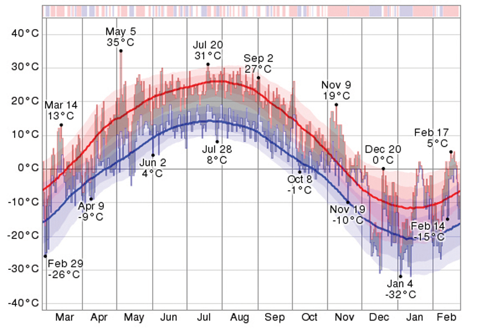
Usual temperature range for this period: Highs, -13 to -1 C; lows: -26 to -10 C.