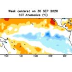
Sea surface temperature (SST) anomalies over the southern Pacific for the week centred on Sept, 30, 2020. (CPC.ncep.noaa.gov)

La Nina to bring colder, drier winter

MarketsFarm — There’s a La Nina poised to exert influence on the coming North American winter, according to Drew Lerner, senior agricultural meteorologist for World Weather Inc. in Kansas. A La Nina generates colder-than-normal temperatures, as opposed to the warm temperatures garnered from an El Nino. Both weather phenomenon can be found over the Pacific


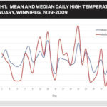
Average, normal or median temperature?

Average, normal or median temperature?

There's really no such thing as a 'normal' high

Maybe it’s the cold weather, or just that I’m getting a little tired of winter, but a couple of my weather-related pet peeves have raised their ugly heads once again and I feel it’s my responsibility to address them. No, it’s not the argument about wind chill, I already tried to tackle that topic; this

Forecast: Nice early-spring weather to continue

Issued March 12, 2018: Covering the period from March 14 to March 21, 2018

Last week’s forecast played out fairly close to what weather models predicted, with a few minor exceptions. Western regions saw a little more cloud and occasional light snow last Wednesday and Thursday, while temperatures to start the week were a little cooler than forecast, thanks to a weak backdoor cold front that moved in from


Weather forecast: Looks like a nice start to winter

Issued: Monday, Nov. 23, 2015 – Covering: Nov. 25 – Dec. 2, 2015

Last week’s forecast played out pretty close to what the weather models predicted. Winter arrived across southern and central Manitoba late last week, with the season’s first significant snowfall hitting central and eastern regions, while the southwest received just a dusting. Temperatures then fell to around average or even a little colder than average over


Warm weather returns to the Prairies late next week

Issued: Monday, August 31, 2015 – Covering: September 2 – September 9, 2015

Last week’s forecast once again played out fairly close to what was predicted, but with a couple of timing issues. For example, the cold front forecasted for last Sunday was a little slow and didn’t push through until Monday morning. This forecast period is going to start off on the warm side, with high temperatures

Mix of sun and scattered thundershowers

Issued: Monday, June 22, 2015 – Covering: June 24 – July 1, 2015

This forecast period is starting off much like the last one. The general flow of the atmosphere is fairly zonal, which means a strong west-to-east flow. Sometimes it’s coming a little out of the northwest, which results in slightly cooler conditions, and sometimes it veers a little southwest, which means warmer weather. The trouble is,


Typical winter temperatures expected

Issued: Monday, Feb. 2, 2015 – Covering: Feb. 4 – Feb. 11, 2015

Well, the cold weather pattern won out, as we saw cold arctic air move in during the last couple of days of January, and it looks like it will stick around for a little while longer. This forecast period will start off with another arctic high drifting southeastward across our region. This should bring us