flooded farmer's field

Excess moisture might trigger more crop insurance claims than frost

Farmers and crop insurance adjusters expected to be in fields this week 
assessing crop damage caused by the Victoria long-weekend storm

Excessive moisture from the May 16-17 storm might result in more crop insurance claims than frost. “From our perspective the amount of rain and snow that came with this storm is probably as big a concern as the frost itself,” David Van Deynze, Manitoba Agricultural Services Corporation’s (MASC) manager of claim services said May 20.

Roller-coaster ride settling into summer weather mode

Issued: Monday, May 25, 2015 – Covering: May 27 – June 3, 2015

You have to love spring across the Prairies. One day it’s cold and snowy and a few days later it feels like summer! It looks like our spring roller-coaster ride is going to continue, but it does appear the ride is coming to an end. After a beautiful weekend and first half of the week,


How are severe thunderstorms created?

All the ingredients can be in place, but good luck pinpointing where the storm will form

I’d said we were going to examine which weather conditions bring long-duration rainfall warnings, and also dig into some of the rainfall records from across southern and central Manitoba in this issue, but that topic will have to wait until next time. An early deadline for this issue due to the long weekend, combined with

man and woman standing beside car

Weather watchers keep eyes on the rural skies

Steinbach’s Storm Ready volunteer weather-spotter pilot program has been active since 2010. EMO and Environment Canada are working to see it expanded and taken up by more communities, say EMO officials
You’re a true weather hound if you volunteer to have a siren go off in your house whenever a storm is brewing. Blumenort resident Amy Ginn gets a rush of adrenalin every time she hears it — especially when it goes off in the middle of the night. “It does get your attention when it


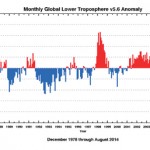
This graph created by the University of Alabama in Huntsville, shows the monthly global lower troposphere temperature anomaly since 1978. The data used in this graph are gathered by advanced microwave sounding units on NOAA and NASA satellites and measures the temperature of the atmosphere from the surface up to an altitude of about eight kilometres above sea level. You can see that since about 2001 global temperatures have routinely been above average.

Nice fall weather moving in

Forecast issued Monday, Sept. 15 - Covering: Sept. 17 – Sept. 24, 2014
Last week’s forecast didn’t work out quite as expected. The strong arctic high did build southward, but it remained farther to the west than originally forecast, resulting in more cloud cover. While some areas did see some light frost late last week, the extra clouds kept most places a little warmer at night and a little cooler

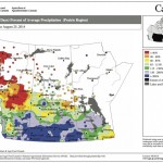
This map shows the total amount of precipitation that has fallen across the Prairies during the 30 days ending Aug. 25, as a percentage of the average expected for this period. This map seems to be a continuation of the maps we’ve seen so far this summer, with above-average amounts of rain over southern Alberta, Saskatchewan and western Manitoba and below-average amounts over northern Alberta.

Late summer/early fall weather

Issued: Monday, September 1, 2014 · Covering: September 3 – September 10, 2014
Last week’s weather ended up following its own rules as a relatively fast-flowing pattern developed across our region, bringing with it rapidly changing weather conditions. For this forecast period it looks like this weather pattern will persist. High pressure that started off this week will quickly be replaced by an area of low pressure that


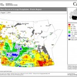
This map shows the total amount of precipitation that has fallen across the Prairies compared to historical averages over the 30 days ending Aug. 7. You can see just how dry it’s been across nearly all of agricultural Manitoba during this period; the only wet area was around The Pas. Farther west, much of northern and western Saskatchewan was wetter than average, as was east-central Alberta.

Off to a warm and dry start

Forecast issued Aug. 11, 2014, covering the period from Aug. 13 to 20, 2014
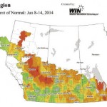
Only problem with last week’s forecast was that we saw two cold fronts move through last weekend instead of just one. The first moved through Saturday, bringing a few quick-moving thunderstorms. The second moved through on Sunday, bringing scattered clouds, the odd shower and cooler temperatures. Hopefully the forecast for this week will be as

Weather map – Western Canada

Here comes another upper low

Covering: June 18 – June 25, 2014
In summer, the one weather feature I don’t like to see is an upper low. They usually mean cloudy, cool, wet weather, which can last for days. So far this month we’ve seen two different upper lows move through and it looks like we might be in for another. Last weekend we saw a fairly


lightning

When thunder roars, GO INDOORS!

Environment Canada – During the summer in Canada, lightning strikes on average every three seconds. Besides causing power outages and forest fires, lightning strikes can also seriously injure or kill. The Canadian lightning Danger Map displays high-risk lightning areas in red. These maps are updated at an interval of 10 minutes and are based on

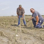
two men in a storm-damage crop

Weather damage hints at new normal under climate change

After western Manitoba has been battered by storm 
after storm, residents say they’re convinced

Kendon Campbell was only half a mile from home when the storm hit his Reston-area farm, but he and wife Shirley were stranded as torrents of water flooded their road and drowned four of their cows. It was the third flash flood the Campbells have experienced this year. “I’ve lived here my whole life, and