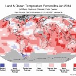
Usually we look at a map that has to do with precipitation, but I thought I would take a break from those maps and look at a map that shows the global temperature anomalies as determined by NOAA for the month of June. Looking at the map, the red-shaded regions saw above-average temperatures while those areas in blue were below average. As you can see, most of the map is red. June 2014 was the warmest June on record, according to NOAA.

A warm and sunny forecast

A boring forecast can be a good thing

It’s been awhile, but it finally looks like we’ll see a prolonged period of dry, warm summer weather. After yet another stronger-than-usual upper low moved across the Prairies last weekend, it looks as if our region will be stuck right in the middle of a blocking pattern. Two stationary areas of low pressure are expected

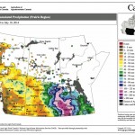
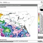
This map shows the total precipitation across the Prairies so far this growing season compared to the long-term average. Most of the Prairies have seen average to well-above-average amounts, with the wettest areas located in a northwest swath from Brandon to just west of Saskatoon.

Unsettled weekend but heat building in next week

Issued: Monday, July 21, 2014 · Covering: July 23 – July 30, 2014

The first half of last week’s forecast was pretty much spot on, as the forecasted trough of low pressure moved through our region last weekend bringing with it a mix of sun, clouds, warm temperatures and a few showers and thundershowers. For the first part of this forecast period high pressure looks to dominate, bringing


weather map of the Canadian prairies

Slight chance of thundershowers

Issued: Monday, July 14, 2014 - Covering: July 16 – July 23, 2014

It just seems to be that kind of year. We saw yet another upper low drop into our region last weekend, bringing with it some record-cold temperatures on Sunday. Winnipeg’s official high temperature on July 13 was 15.7 C, which easily broke the previous record for the lowest daily high of 16.7 C, set back

Summer flood bulletin #15

Province of Manitoba – Portage Diversion Flows on the first crest on the Assiniboine River at the Portage Reservoir crested at midnight last night at 52,100 cubic feet per second (cfs).  Flows on the Portage Diversion are approximately 34,100 cfs and flow on the Assiniboine River immediately downstream of the diversion is 18,000 cfs. The


No more upper lows – but still unsettled

No more upper lows – but still unsettled

Covering: July 2 – July 9, 2014

By the time this forecast period rolls around it looks like we’ll finally be finished with upper lows. I can’t promise this will be the last one we’ll see, but the current weather models aren’t showing any more, at least out to the middle of July. This doesn’t mean we won’t see more rain. This

Flood bulletin #25: May 1

Province of Manitoba media bulletinSummaryBirdtail Creek Water was released yesterday from behind a culvert blocked by ice at the base of a former railway embankment near Birtle. The water reached Birtle yesterday, causing a 10-inch rise in water levels at the bridge on Centre Street.  Reports indicate there is approximately 1.5 feet of clearance under


Possible El Niño developing this summer

Any large-scale change in the state of the Pacific is bound to have an impact elsewhere

I received an email the other day asking about El Niño and what effect it might have on our part of the world, should one develop. For quite a while now the Pacific has been in a neutral El Niño Southern Oscillation (ENSO) phase, but there is some mention of an El Niño event possibly

Will this be the coldest winter since 1918?

December, January and February have all been below the average just three times

There has been a fair bit of talk and media coverage on the cold weather we, and much of central and eastern North America, have seen so far this winter. For this issue I thought I would dig into the weather data and try to see just how cold we have been. First of all,


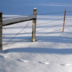
Snow and a barbed wire fence.

Warm, cold and the polar vortex

Believe it or not, December 2013 was one of the warmest ever for the planet

The global weather numbers are in for December 2013, and it turns out that despite the cold weather parts of North America have been experiencing, the planet on a whole continues to be running a temperature. According to data from the U.S. National Oceanic and Atmospheric Administration’s (NOAA) National Climatic Data Center, NASA and University

A cold and snowy month ahead?

Another month has come and gone and 2013 is quickly coming to an end. While it is a little too soon to make a summary of this past year’s weather, it’s time to see how November’s numbers added up. November started off fairly nice, with daytime highs pushing the 10 C mark in the first