After a warm start to the year, temperatures took a decidedly cold turn in February. Thanks to a southward shift in the infamous Polar Vortex, all the major reporting stations recorded well below average temperatures in February — even with the blast of warm air that invaded the Prairies during the last week of the month, average temperatures were just not able to recover. It’s hard to make up for -40 degree Celsius weather, which resulted in average daily temperatures that were 20 C colder than average, with a few warm late February days that were five to 10 C warmer than average.
Here is the breakout of temperatures and how they compared to average. Since I had to write this one day before the end of the month, I manually adjusted the mean or average monthly temperature based on the forecasted high and low for that day.
Polar vortex on the Prairies
Read Also
Winterkill threat minimal for Northern Hemisphere crops
The recent cold snap in North America has raised the possibility of winterkill damage in the U.S. Hard Red Winter and Soft Red Winter growing regions.
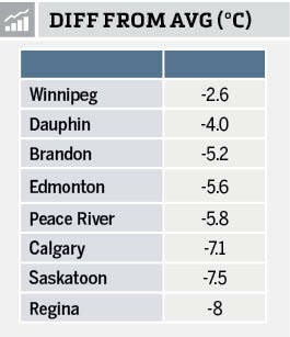
Looking at the data we can see that both Regina and Saskatoon found themselves at the heart of the polar vortex, with both locations reporting not only the coldest actual temperatures but also the coldest difference from average. If you look at the difference from average you can see that Saskatchewan was the coldest region with Alberta the next coldest, while Manitoba was still cold but came in much closer to average.
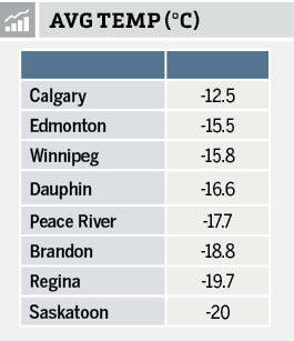
In fact, February was not just colder than January, but it was actually colder than January’s average temperature right across all of the stations with the exception of Winnipeg. Winnipeg recorded a mean monthly temperature in February of -15.8 C while January’s mean temperature was -16.4 C.
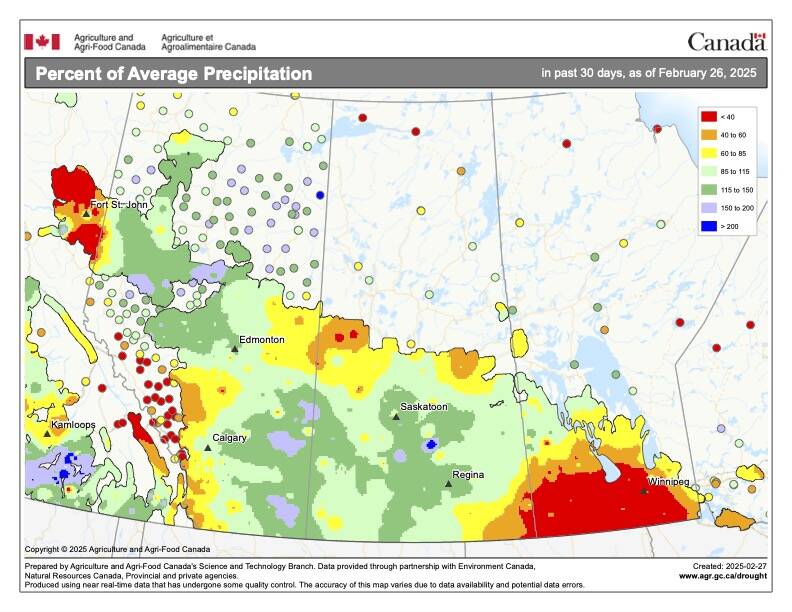
Looking at precipitation, the latest map shows the percentage of average precipitation across the Prairies over the 30-day period ending on Feb. 26. The actual amounts, at least using the main reporting sites, were below average for the month as a whole except for Regina.
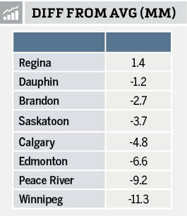
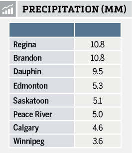
Overall, February was a dry month across the Prairies. Only Regina reported above average precipitation. Of note, you can see that February is the driest month with most locations only seeing, on average, between 10 and 15 millimetres of water-equivalent precipitation.
When all the numbers are added up it is very clear February was colder and drier than average.
Weather forecasts for spring 2025
Now on to our new look at the latest and greatest long range weather predictions. As usual, let’s start our look with the almanacs. The Old Farmers Almanac is predicting a slightly colder and snowier than average March followed by a very warm April with near average precipitation. The May forecast is calling for slightly above average temperatures and precipitation. The Old Farmers Almanac, which as you know, I like to poke fun at as they can be a little cryptic, is predicting a colder and wetter than average March followed by a near average temperature and precipitation in April as they mention fair weather several times during the month. May is a tough one to figure out as they don’t really mention temperatures only fair conditions which I will take as average temperatures. Precipitation looks to be above average as they mention unsettled weather several times.
Moving on to the computer-based forecasts, we start with NOAA’s latest three month forecast. Hopefully we don’t lose access to this with all the cuts currently taking place with our neighbours to the south. This model is calling for below average temperatures over the western half of the Prairies with near-average temperatures in the east. Their precipitation forecast is calling for near-average amounts right across the Prairies over the next three months.
Next is the CFS model. It calls for above-average temperatures across all three months, with March being the warmest compared to average. Their precipitation forecast is a little more complicated. It is predicting average precipitation in March with southern Manitoba seeing below-average amounts. April is forecast to be above-average across much of southern and central Alberta and Saskatchewan along with central Manitoba. May looks to be relatively dry with most regions seeing near- to below-average precipitation, with Manitoba expected to be the driest.
Next up is the Canadian CanSIPS model. This model predicts below-average temperatures in both March and April, with near to slightly above-average temperatures in May. Their precipitation forecast is calling for average amounts in March with below-average amounts in both April and May. Last on our list of computer forecasts is the European or ECMWF forecast. It is calling for near- to slightly above-average temperatures with the extreme southern Prairies seeing the best chance of above-average temperatures. The precipitation forecast is for near- to below-average amounts across all three months.
Last — and actually least — is my prediction. I think March will see slightly above-average temperatures along with near- to slightly below-average precipitation. April will be an average month both temperature and precipitation wise. Finally, May will see warmer and wetter than average conditions.