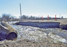
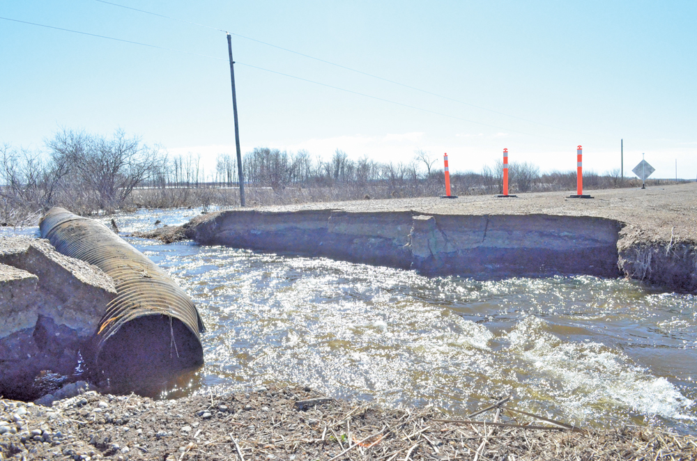
Flooding was on the decline in parts of Manitoba late last week, but the Assiniboine River was on the rise.
Simultaneous peaks of the Souris and Assiniboine rivers raised concern downstream. Flow into the Portage Reservoir was expected to reach 41,000 to 44,000 cubic feet per second April 12-14.
The region between Portage la Prairie and Headingley remained under flood warning into the weekend, as flows were expected to reach 15,000 cubic feet per second downstream of the diversion by April 10.
“(That’s) getting towards the upper limits of the Assiniboine River, but still within its capacity,” Kam Blight, RM of Portage la Prairie reeve, said. “It also means that there’s going to be high flows going down the Portage diversion.”
Blight estimated that between 26,000 and 29,000 cubic feet per second might be seen along the diversion.
“Naturally, that’s a concern as well as there’s lots of homes and residents and farmland along the diversion, plus the impact that it has on Lake Manitoba,” he said.
The river remained well in its banks at press time, although river tributaries had backed up, creating overland flooding. Ice jams along the Assiniboine River had subsided, although the RM of Portage la Prairie reported an influx of water previously backed up by ice.

“Basically what’s happened is it’s stopped normal waters from being able to get into the Assiniboine River that would normally disappear before the high river levels came through. The ice jams created artificially high levels and local water cannot get away,” Blight said.
He noted that dikes were frozen, increasing holding capacity.
Farther west, sandbagging was underway in Brandon ahead of the Assiniboine River’s expected crest.
The City of Brandon’s Emergency Response Team was monitoring water levels, which reached 1,178,68 feet above sea level as of mid-morning April 9. The river is expected to reach 1,180 feet above sea level at its peak, the province has said.
Flood protection was put in place along Provincial Road 459 and the eastern end of the city along the river.
Read Also

Forecasting spring 2026 weather on the Prairies
What weather can farmers expect across Manitoba, Alberta and Saskatchewan as they head into seeding? Plus: a lesson on what makes the seasons turn
Less sandbagging was required this year than in previous flood years, Greg Brown, volunteer co-ordinator, said.
About 35 volunteers spent over two hours placing about 3,000 sandbags on a property on the easternmost limits of the city April 9.
“This was one of the only properties in Brandon that was at risk,” Brown said. “It’s outside the primary dike system, so we had to build a sandbag dike around it.”
The temporary wall was about three feet shorter than in either 2014 or 2011, Brown said.
Temporary dams were also placed on the city’s First Street river crossing. The city does not anticipate any evacuations due to flood water.
The City of Brandon also warned the public to stay away from the river and off dikes, as it might obstruct heavy machinery and construction crews.
Flood warnings remained in effect along the upper Assiniboine River from the Shellmouth Dam to Holland and on all points along the Souris River through the weekend.
The town of Souris saw falling water levels April 5-6 as ice floes subsided.
Souris Mayor Darryl Jackson said the town was told to expect the river to crest between April 8-10, earlier than the initial April 9-13 forecast.
“At this point, we’re in good shape,” he said. “We’re watching a couple of homes along the river, but at this point the water is well below threatening.”
All flood watches along the Plum Creek were lifted April 7, although Souris’s Victoria Park remained under water as the creek backed up from the Souris River.
High water on lakes
Cottage owners on Pelican Lake were keeping a wary eye to the water as outflows hit capacity late in the week.
“Inflows to the lake have crested,” the province reported April 7.
“However, there is still a large volume of water to come and the lake is projected to rise high enough that flood protection will be required for properties around the lake.”
Rock, Oak and Dauphin lakes also remained under flood warning into the weekend.
The Pembina River, which made headlines in late March when flood waters closed the international border between Gretna and Neche, was expected to crest a second time over the weekend.
Equipment was on standby as of April 7 in Gretna in case another partial dike closure was required.
Wes Unrau, chief administrator of the RM of Pembina to the west, said some sandbagging was required in La Rivière and the municipality saw some overland flooding, which has subsided.
“It went across a couple of roads, nothing too terrible,” he said. “I understand that the Pembina has crested over the banks in a couple of spots.”
Flows along the Red River crested April 5 while flood warnings and watches were lifted along the La Salle and Morris rivers soon after.