

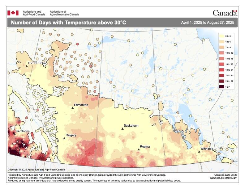
After a cooler than average July where all of the main reporting stations reported below average temperatures, August saw a reversal with all of them reporting above-average temperatures. While it was a warmer-than-average month, precipitation was closer to average with a few locations reporting higher-than-normal amounts and a few a little below normal.
As usual, I am going to stick with the format I have been using now for a while and that is, we will look at the average temperature rankings for the main reporting centres in each province, followed by a look at how those actual temperatures compare to average. We will then follow that up with a look at precipitation rankings and how they compare to average. Then we will jump into the long-range outlooks and see if there have been any changes to the thinking of the weather models for the fall forecast.
Read Also

Why is the sky blue?
The colour of the skies, on the Prairies and elsewhere, tells the story of the paths sunlight takes as it enters Earth’s atmosphere, Daniel Bezte writes.
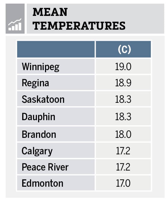
When we examine August’s temperatures, we can see that Winnipeg was the warmest location followed closely by Regina while the cold spots were found in Alberta.
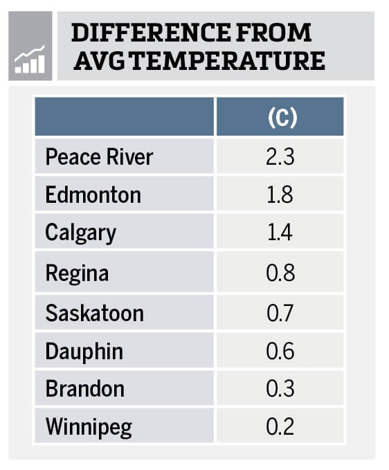
Looking at the difference from average we see almost a reversal of the data with the stations in Manitoba coming in only slightly above average with Winnipeg at the bottom of the list. Meanwhile, the Alberta locations, while being overall the coolest locations, were the warmest compared to average.

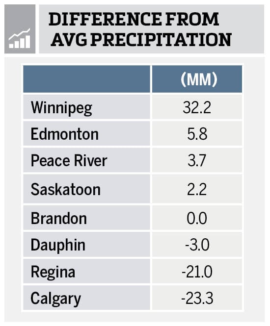
Looking at August’s precipitation values for the main reporting centres we can see that it was a bit of mixed bag with Winnipeg being the wettest location and Regina and Calgary coming in as the driest. Overall amounts came in pretty close to average for a large portion of the Prairies.
So overall, it was a warmer-than-average August with near-average precipitation. If we look back at the different forecasts for the month, I will have to give the win to the CFS model which predicted above-average temperatures with near-average precipitation across most regions, with southern Manitoba and Alberta forecasted to see above-average amounts. While it missed out on the above-average amounts in southern Alberta, it did get the above-average amounts in Manitoba.
Now on to our look at the latest fall forecasts. Starting off as usual with our two almanacs. The Old Farmer’s Almanac is calling for near- to slightly above-average temperatures in September, October and November, along with near-average amounts of precipitation. The Canadian Farmers Almanac, after doing our usual reading between the lines, appears to be calling for the September to November period to be cooler and wetter than average as they mention chilly or cold several times along with unsettled, showery-stormy conditions.
Moving onto the different weather models. NOAA’s forecast, extrapolating northwards, looks to be calling for near-average temperatures and precipitation right across the Prairies from September right through to November. Our next weather model is the CFS, and it is currently calling for well above-average temperatures in September, transitioning to slightly above-average in October and near-average in November. Their precipitation forecast is calling for below-average amounts in September, with October and November coming in around near- to slightly above-average with southern Manitoba and western Alberta seeing the wettest conditions.
Next is the Canadian CanSIPS model, but since I am writing this with a couple of days still left in August, the latest model run is not yet available. I will check and report on it in the next article. Last on our list of weather models is the European or ECMWF model. It is calling for warmer-than-average temperatures in September and October, with November coming in near-average. Their precipitation forecast is calling for near-average amounts for all three months with parts of southern and western Alberta seeing slightly above-average values.
Finally, my throw at the weather prediction dart board. I am leaning towards a warmer-than-average start to fall with temperatures transitioning to near-average by November. Precipitation will be near-average in September with October and November coming in near- to slightly above-average. In our next issue we will wrap up our look into severe summer weather by finishing our look at extreme rainfall.


