In last week’s article we began our reassessment of how clouds form. We looked at the collision-coalescence process in which tiny cloud droplets collide and stick together, allowing them to grow big enough to fall as rain.
This process occurs within warm clouds where temperatures remain above the freezing point. In this part of the world, warm clouds do not occur that often, so we also examined the Bergeron process. This process is how, in cold clouds, ice crystals will grow quicker than water droplets, forcing the moisture in a cloud to create ice crystals and snowflakes instead of water droplets.
What I forgot to say is that tiny water droplets in clouds that are below 0 C can often stay in liquid form. These droplets are known as supercooled droplets.
Read Also

Forecasting spring 2026 weather on the Prairies
What weather can farmers expect across Manitoba, Alberta and Saskatchewan as they head into seeding? Plus: a lesson on what makes the seasons turn
Now let’s examine how clouds are classified. If we were to define a cloud, we could say it is a visible collection or aggregate of tiny water droplets or ice crystals floating or suspended in the air. Stealing a line from Meteorology Today, “some clouds are found only at high elevations, while others nearly touch the ground. Clouds can be thick or thin, big or little — they exist in a seemingly endless variety.”
Identifying the different types of clouds can be tough, but with some practice, you can become reasonably proficient at identifying them.
Our current method of naming and classifying clouds was developed in 1803 by Luke Howard, an English naturalist. His system employed the use of Latin words to describe clouds as they appear from the ground.
Clouds that appeared to look like sheets were called stratus, which is Latin for layer. Puffy clouds were called cumulus, which is Latin for heap. Wispy clouds were called cirrus, which is Latin for curl of hair, and finally, rain clouds were called nimbus, meaning violent rain in Latin.
In essence, Howard’s system had four different cloud types, which could then be combined to cover other types. For example, stratus clouds that have rain falling from them would be called nimbostratus; cirrus clouds that form a layer would be called cirrostratus, and so on.
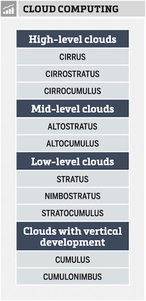
In 1887, Abercromby and Hildebrandsson expanded Howard’s system by creating four different groups that clouds can be divided into, based on height. These would be high clouds, middle clouds, low clouds and a fourth group for clouds that span more than one region — or what we call ‘vertically developed’ clouds.
This is the system we use today. Clouds are classified by the height at which they occur and then by their appearance. The table here shows the four major cloud groups and their types.
This addition to the naming and classifying of clouds does at first seem fairly simple and straightforward, but there are a couple of things that make it confusing.
First of all, we have cloud types of stratus (layer) and cirrus (wispy). To add in the height of the cloud we could use the term ‘cirrus’ for all high clouds, ‘alto’ for middle-level clouds, and ‘stratus’ for low-level clouds. So, we are using the same word, cirrus, to mean two different things: high and wispy. When we take a closer look, though, it does make some sense.
Wispy cirrus clouds only occur at high altitudes, so anything high up in the atmosphere will either be cirrus or have ‘cirro’ attached to the front of it. Mid-level clouds are easy, as we simply add the term ‘alto’ to the cloud type.
Naming low-level clouds works the same as with the high-level clouds, except this time we use the term ‘stratus’ to describe the cloud. For example, low-level cumulus clouds would be called stratocumulus.
Next time we will look at how September’s weather stacked up, and then we’ll take a look at the latest long-range forecasts for October, November and December. Barring any unusual weather events in our region in early October, we will continue our look at clouds and begin to examine each type and what clouds usually tell us about our weather.