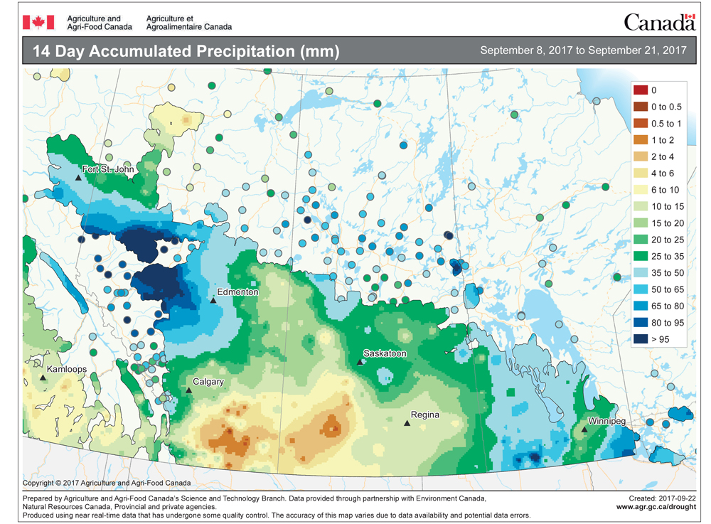
It looks like we are going to stay on the lucky or good side of the battle between cold and warm air for most, if not all, of this forecast period. Considering last week’s weather I am going to lean toward the warmer forecast model for this period – let’s hope it’s right!
The models show our region continuing to be stuck in the middle of a strong northwesterly flow. To our north and east cold air is in place while to our south and west, warmer air should prevail. Typically with this pattern at this time of the year the cold air would win out but it looks more and more like the warm air will be victorious.
Read Also

Forecasting spring 2026 weather on the Prairies
What weather can farmers expect across Manitoba, Alberta and Saskatchewan as they head into seeding? Plus: a lesson on what makes the seasons turn
For the first part of this forecast period we will be stuck under the northwest flow and the cold air should win out. Around mid-week it looks as if we will see an eastward shift in air masses, resulting in milder air starting to work its way into our region. As the northwest flow slides eastward, a region of low pressure is expected to drop southward late in the week. The strength of this system and how fast the northwesterly flow slides eastward will control whether eastern or western regions see any light snow around Friday or into Saturday.
Over the weekend and into next week it looks as if the general flow over our region will become westerly. This should help to keep temperatures on the mild side. I expect highs to be around -5 C or slightly warmer on most days (depending on sunshine) and overnight lows around -15 C. It looks like most of the major weather system will stay to our north during this period, but this pattern is a little too springlike this early in the year, so we will have to be watchful since it wouldn’t take much to push these systems southward.
Usual temperature range for this period: Highs:-18 to -3 C.Lows:-30 to -12 C.