Reuters — A tornado spun for several hours through southwestern Manitoba late Monday in a fierce Canadian Prairie storm that caused flash flooding and shredded part of a highway.
No injuries or major damage was reported, according to a statement by Environment Canada, federal weather forecaster.
“What was just shocking was the duration on the ground, for 2-1/2 to three hours,” said David Phillips, senior climatologist at Environment Canada.
Photos on social media showed torn-up asphalt on one Manitoba highway and pooling water in Regina, Saskatchewan.
Read Also
Prairie forecast: Warm start then cooler air to move back in
While spring appears to be gaining a foothold across the western Prairies, it continues to struggle across the eastern regions. This forecast period looks milder than the last, but weather models are still not showing a clear or sustained shift toward a more spring-like pattern.
A large tornado developed near Pierson, Manitoba, on Monday evening, moving north of the town of Virden by late evening, Environment Canada said.
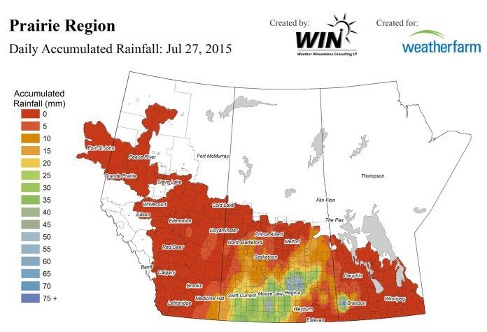
Further west, the storm dumped 78 millimeters (3.1 inches) of rain on Regina, part of a crop-growing area desperate for rain this summer.
The downpour was the wettest July day on record for Regina, the Saskatchewan capital, and included 18 hours of rain, Phillips said.
So much rain alleviates severely dry conditions, but is not an immediate fix, he said.
Near the Canada-U.S. border, Coronach, Saskatchewan, recorded 85 mm (3.3 inches), according to Environment Canada data. Heavy rain largely missed Alberta, where some of the driest farms are located.
Environment Canada warned of further heavy rainfall on Tuesday for parts of southern and central Saskatchewan.