

It seems like every year around this time I start getting a lot of questions about when we should expect the first snowfall, or when I expect winter will begin. Even with all the warm weather we have been experiencing lately, this year is no different. In fact, the general murmurings I have been overhearing are that we are going to pay for all of this warm weather with a shot of winter weather before the end of the month. So, while I have written about this on several occasions over the last 16 years, I thought it was time to revisit the question of when we can expect the first snow to fall and when we should “normally” expect winter to arrive. Please keep in mind that just because I am writing about this now does not mean I am guilty of bringing about any colder weather or early snows!
Read Also

Forecasting spring 2026 weather on the Prairies
What weather can farmers expect across Manitoba, Alberta and Saskatchewan as they head into seeding? Plus: a lesson on what makes the seasons turn
As we have been learning over the years, certain weather-related questions sound simple enough, but when you actually start to look at the question it becomes tougher to figure out. The tough part about trying to figure out when winter begins is how to define just what constitutes the start of winter! Should it be the first significant snowfall? How about when the high temperature consistently stays below 0 C — or should we simply use the astronomical date of Dec. 21, or maybe just stick to the meteorological date of Dec. 1?
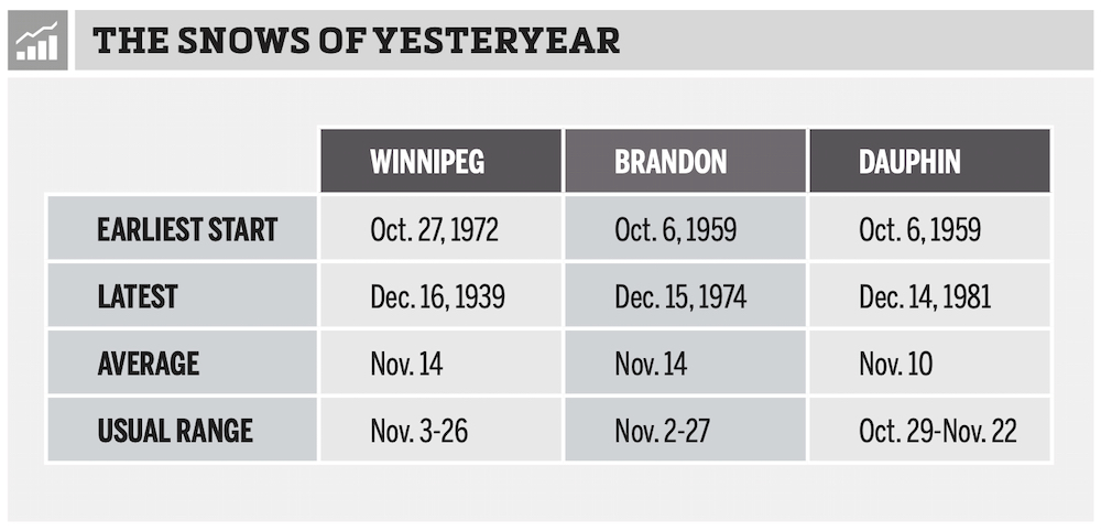
I think most people would agree winter doesn’t really arrive until you have snow on the ground, so for us, I use this as our measure of when winter arrives. Even narrowing it down to this still has some problems. What if, for example, it snows five centimetres on Oct. 22 and then by Nov. 8 it has all melted and we don’t receive any more snow until Dec. 4? Did winter start on Oct. 22 or Dec. 4? For me, I call this situation a false start to winter, and I would record the winter in this example as starting on Dec. 4. Once I determined this, I went through the snowfall records for Winnipeg, Brandon and Dauphin, and came up with the results in the table shown here.
From the table below we can see all three regions of agricultural Manitoba have seen winter start in October and as late as mid-December. Winnipeg and Brandon both have an average date for snow to stick around of Nov. 14, with Dauphin being four days earlier on Nov. 10. The “usual range” is a measure of the standard deviation around the average. It indicates the range of days within which we should expect winter to begin. If winter begins before or after these dates, it is a fairly unusual year.
Other questions I often receive are whether I think we will get a lot of snow this winter and are we going to see any major snowstorms. Looking back over previous years’ snowfall events in our three different regions, I found that large single-day snowfalls are fairly rare events. When I looked at the number of times Winnipeg, Brandon and Dauphin received more than 10 cm of snow in one day over the last 70 years, I was surprised to find out that on average, all three locations have this occur a little less than twice per winter. When we bump up the single-day snowfall to 15 cm or more, this occurs on average, a little less than once per winter. If we increase the single-day snowfall to 20 cm or more, the frequency of occurrence drops down to around once every five years. Finally, to show how rare really big snowstorms are in our region, if we take a look at the probability of receiving 30 cm or more in one day, we will find that kind of event only occurs once every 30 or so years.
One thing that I need to point out is, from December to February, agricultural Manitoba, on average, receives about 50 cm of snow. So, all it takes is one big storm and we’ll be at average or even above average for the winter. Therefore, it is very hard to predict whether winters will be wet or dry as it often only takes one storm to make a wet winter!
Insulation
Another question that comes up with the talk of snow is cold temperatures – just when will the cold temperatures move in? The answer to that is almost always tied to when the snow moves in. While we can get some cold temperatures without snow covering the ground, to get extremely cold temperatures and sustained cold temperatures we need to have snow cover.
Snow cover acts in a couple of ways to contribute to colder temperatures. First, it insulates the ground, trapping the ground’s heat and preventing it from warming the air above it. Secondly, snow has a very high albedo; that is, it reflects a very large proportion of the sun’s energy. So instead of the sun’s energy being absorbed by the ground and then released to warm the air, it gets reflected and we don’t warm up much during the day. Finally, snow, simply put, is cold! We really notice this in the spring, but having snow on the ground at any time of the year acts like a refrigerator to keep temperatures down.
In the next issue, unless we get a really big storm to discuss, maybe we will continue our look at snowfall and snow-related topics. Too early?


