

We have a lot of ground to cover in just one instalment of this column.
We will start off with a quick look back at the weather across the Prairies in 2025. Then we will look at the global temperature rankings last year and how they compared to other years. Finally, we will look ahead to see what the weather forecasters are predicting for the final few months of this winter and what spring might have in store for us.
Weather on the Prairies
Read Also

Forecasting spring 2026 weather on the Prairies
What weather can farmers expect across Manitoba, Alberta and Saskatchewan as they head into seeding? Plus: a lesson on what makes the seasons turn
Let’s look at the average yearly temperatures across the Prairies for the main reporting stations in each province, then compare those values to the long-term averages.
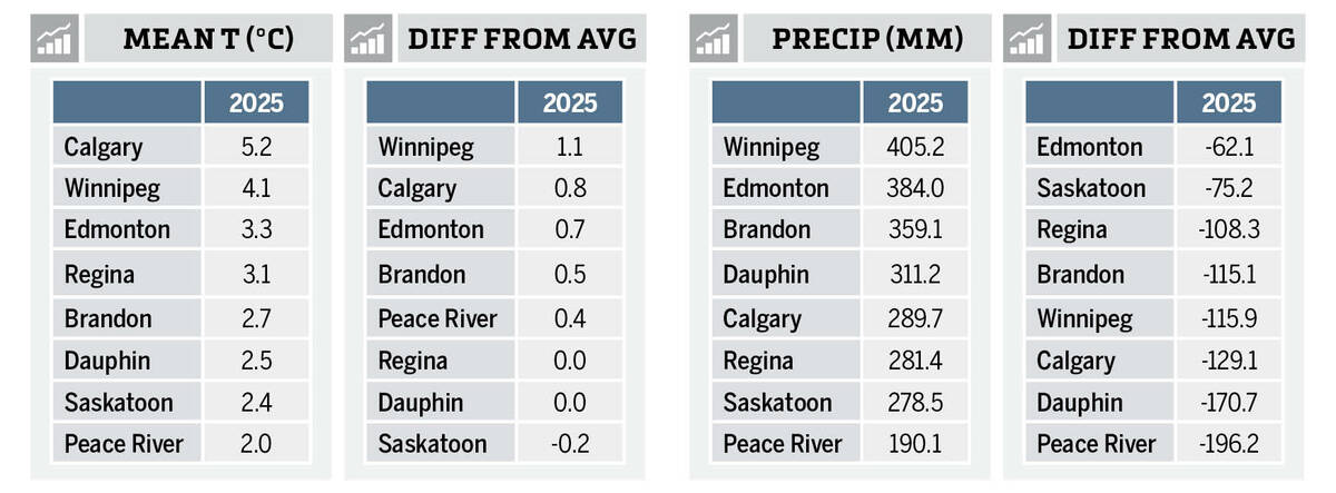
We can see that Calgary’s yearly mean temperature surpassed Winnipeg by more than one degree. That’s because Calgary’s yearly temperature in 2025 was very similar to the previous years, while Winnipeg came in nearly 1.5 C cooler in 2025.
Mean temperatures across the remainder of the Prairies varied from 3.3 C in Edmonton to a cool 2.0 C in Peace River.
Next, let’s compare these values to the long-term averages, where we can see Winnipeg ended up being the warmest location when compared to its average, with Calgary coming in a close second. The cold spot was Saskatoon, which was the only location reporting a yearly temperature that was below the long-term average.
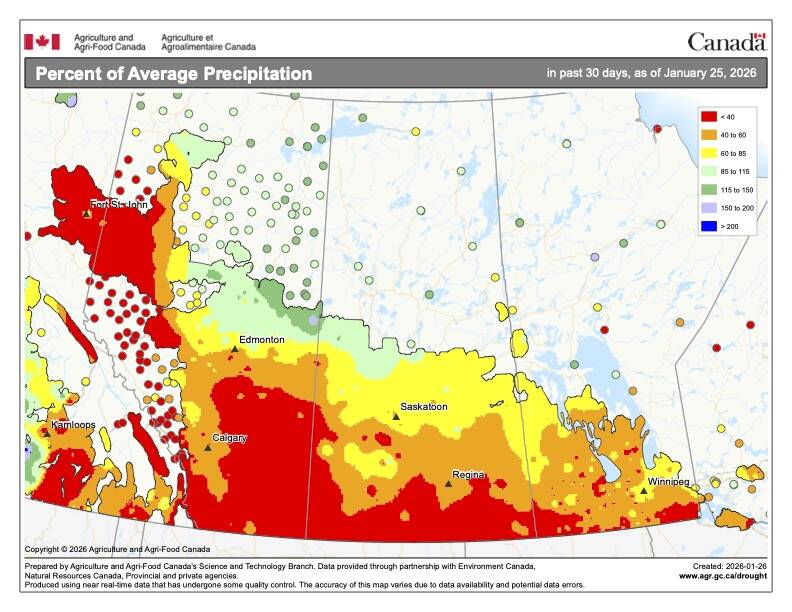
Next up, yearly precipitation. Southern Manitoba was the wet spot in 2025, with three of the top four wettest locations occurring in that province. Peace River was by far the driest location with only 190 mm of precipitation recorded during the year. Let’s look at how these amounts compare to average.
From this data we can see that there were no ‘wet spots’ as all locations reported below average precipitation in 2025. The least-dry location compared to average was the region extending from Edmonton eastward to Saskatoon. Not surprisingly, Peace River was also the driest location compared to average, receiving less than 50 per cent of the average long-term precipitation.
So overall, 2025 saw near-average temperatures across the Prairies, with well-below average precipitation.
Global weather look
Moving on to global temperatures for 2025, all of the major reporting agencies — including NASA, NOAA, the European Copernicus program, Japan, the UK Met Office, and Berkeley Earth — ranked 2025 as either the third-warmest year on record or tied for second. The warmest year on record remains 2024, with 2023 and 2025 essentially in a statistical tie just behind it.
The mean global temperature for 2025 was approximately 1.44 C above the pre-industrial average. This compares to 1.52 C in 2024 and 1.47 C in 2023. Of particular note, the 11 warmest years on record have all occurred within the past 11 years.
Several other notable climate-related milestones occurred in 2025, including:
- the highest global ocean heat content on record,
- the second-warmest troposphere,
- record-high global sea levels and atmospheric carbon dioxide concentrations and
- record-low Arctic sea ice extent.
A fifth point is also worth highlighting. While 2025 was slightly cooler on a global scale compared to the previous two years, that near-record warmth occurred during a La Niña year. Typically, La Niña conditions are associated with a modest reduction in global temperatures. However, while last year’s La Niña was only moderate in strength, its impact on global temperatures was virtually negligible.
The outlook for 2026 suggests a good chance of another top-five warmest year on record, although lingering La Niña influences will likely prevent it from setting a new record.
Farm weather ahead for 2026
Turning now to our final topic: late winter and early spring outlooks. As usual, we begin with the Old Farmer’s Almanac, which is calling for above-average temperatures for the remainder of winter, along with near- to slightly above-average precipitation. This outlook then transitions to near-average temperatures and precipitation during the spring months.
Looking next at the weather models, NOAA’s latest three-month outlook suggests below-average temperatures to finish winter and begin spring, accompanied by above-average precipitation. Conditions then trend toward near-average temperatures and precipitation later in the spring.
The CFS model is calling for above-average temperatures in February, below-average temperatures in March, and near-average conditions in April and May. Its precipitation outlook shows near- to above-average totals across all four months.
The European model forecasts near-average temperatures in February and March, warming to slightly above-average in April and May, with precipitation near- to slightly above-average throughout the period.
Finally, the Canadian CanSIPS model predicts well below-average temperatures from February through April, with May returning to near-average values. Precipitation in this model is near-average in February and March, then below-average in April and May.
As is often the case, these differing signals make it difficult to draw firm conclusions. Relying largely on experience and gut instinct, I am leaning toward near- to below-average temperatures in February and March, followed by a warming trend to near- or above-average values in April and May.
Precipitation, always the most challenging element to forecast, appears likely to be below average in February, near average in March, and above average in April and May.
As always, we now sit back and watch how it all unfolds.


