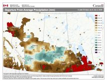
Unfortunately, last week’s forecast was right on the money, as a large upper-level low broke off and stalled well to our south. This resulted in a very wet and cool weekend across nearly all of southern and central Manitoba. For this forecast period it looks like our weather pattern will continue to undergo changes as it tries to settle into a more summer-like pattern.
After a nice warm start to this forecast period, with highs on Wednesday expected to be close to 20 C, it looks like we’ll cool down during the second half of the week. A large area of low pressure crossing northern Canada will drag a cold front down on Thursday. I don’t think we’ll see any precipitation with this front, but there will be a mix of sun and clouds, with daytime highs cooling down to around 10 C and overnight lows around the 0 C mark.
Read Also

Thunderstorms and straight-line winds
Straight-line winds in thunderstorms can cause as much damage as a tornado and are next on our weather school list exploring how and why severe summer weather forms.
Over the weekend an area of low pressure is forecast to track across the Dakotas, but with high pressure to our north, any precipitation from this low should stay south of the border. Temperatures will be nice, with highs around 15 C in areas that stay sunny, with cooler temperatures over extreme southern regions that have the best chance of seeing clouds.
The first half of next week also looks to be fairly mild and dry as weak high pressure dominates. During the second half of next week, the weather models show several storm systems coming in off of the Pacific, bringing several chances for wet weather into the early part of May. Currently, it looks like most of this wet weather will stay to our south thanks to high pressure sitting to our north, but after a fairly wet start to April, this pattern definitely bears watching.
Usual temperature range for this period: Highs: +6 to +20 C; lows, -4 to +5 C.


