I am going to take a break from covering our top weather stories of 2016 and instead look at a weather story unfolding across our region right now. After a very late start to winter across the Prairies, we saw Old Man Winter arrive with a vengeance a week into December. Temperatures plunged across Manitoba, with overnight lows bottoming out in the mid-minus-30s by the 17th of the month. Everyone started to talk about how this winter will likely continue to be cold and snowy — just like what a typical La Niña winter should be, or was forecast to be.
Read Also

Forecasting spring 2026 weather on the Prairies
What weather can farmers expect across Manitoba, Alberta and Saskatchewan as they head into seeding? Plus: a lesson on what makes the seasons turn
We did see a little bit of a reprieve from the frigid cold during the last couple of weeks of December before another frigid blast moved in to start the new year. This got people talking all over again as to whether or not this was going to end up as a cold, miserable winter. Fast-forward to the middle of January, and within a week of seeing warnings for extreme cold, nearly all of Manitoba and Saskatchewan was breaking mid-January heat records. Now all the talk I hear is about the unusual winter warmth we are experiencing and I find myself asking, “When do we start to see this unusual warm winter weather as ‘usual?’”
A quick look back at the last 10 years of winter weather across our region begins to spell out a story pointing toward the fact that these warm, prolonged shots of winter weather are becoming the norm, and are no longer unusual.
Over the past 10 years, looking at the extended winter season here in southern and central Manitoba (November to March) we have seen 60 per cent of the months with above-average temperatures, 10 per cent with near average, and only 30 per cent with below-average temperatures. Most of the below-average months came in 2013 and 2014 when our region got “stuck” under an extreme Arctic vortex. The coldest month during this period occurred in December 2013, with a mean monthly temperature 6.3 C below the long-term average. Looking at the warmest months, February 2016 came in 8.3 C above average, with two other months coming in at 7 C above average. Comparing the intensity of warm snaps versus cold snaps during this period, it definitely appears as though the warm snaps are winning.
Snaps
Let’s look at this winter’s cold and warm snaps. The December cold snap began Dec. 9 and lasted until the 18th for a total of 10 days. All 10 days recorded daytime highs and lows that were below average. The average daytime high was -18.5 C, about 9 C below average and still within the usual temperature range. The average overnight low was -28.7 C, about 10 C below average and just within the usual temperature range for that time of the year. For what I was able to find, no record lows were set during this cold snap.
The latest warm snap began on Jan. 15 and by Jan. 23 was in its ninth day. Extrapolating using the latest forecast, it looks like this warm snap will last until at least Jan. 28, making it 14 days long. During this period the average daytime high looks like it will come in around -1.9 C, which is about 11 C above average and over 3° beyond the usual temperature range for this time of the year. When it comes to overnight lows, the numbers really become impressive. The average low during this period was around -8 C; this is 16 C warmer than the long-term average. Heck, it is warmer than the average daytime high for this time of the year. I have already talked about how a warming planet will exhibit much of the warmth in the overnight hours and this, and other data, continues to support that.
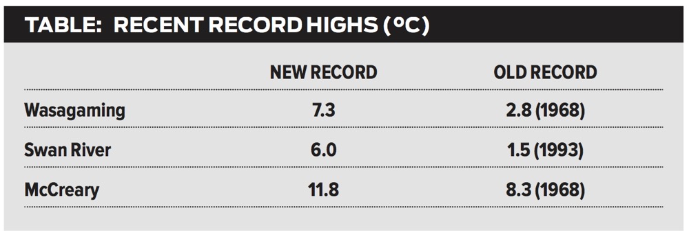
During the warm snap, several daytime highs were broken right across Manitoba. A couple of the most impressive ones that I saw are in the table shown here.
Along with all of the daytime-high records that were set, there were even more overnight-low records set. Unfortunately, it is tougher to dig into these records, but just looking at Winnipeg, it broke the record for warmest overnight low on Jan. 20, 21, 22 and 23. Not just by a little bit, but by as much as 4 to 5 C. With similar overnight lows recorded across most regions, I wouldn’t be surprised if nearly every station broke at least one or two of their overnight records as well.
While we may have seen some cold weather this winter, it doesn’t even compare in magnitude to the warm snaps we are currently experiencing. Looking back over the last 10 years this overall trend continues. Some may argue about the winter of 2014 and all the cold records that were broken that winter. When you actually look at that winter, yes, it was cold, but not very many daily cold records were broken. What made that winter so brutal and record breaking was the duration of the cold, not its intensity. What made last winter and this winter’s warm spells record breaking are both their intensity and duration — a pretty good sign that even our part of the planet is warming, whether you want to believe it or not.