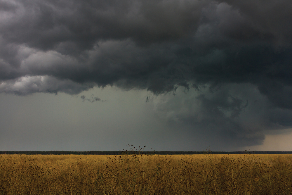
What makes a garden-variety thunderstorm an event to truly remember?
In the last issue we discussed humidity and dew point, and no, I did not realize at the time we were going to see some ridiculously high dew points during the short-lived heat wave that hit us on June 19.
If you recall the article, life-threatening dew points have begun to occur in some subtropical regions, with dew points hitting 35 C. During our one- to two-day heat wave some areas recorded dew points in the 25 to 26 C range — very humid weather, which made a lot of people uncomfortable. Now imagine having a dew point 10 C warmer and you can start to visualize just how dangerous those types of humidities can be.
Read Also

Forecasting spring 2026 weather on the Prairies
What weather can farmers expect across Manitoba, Alberta and Saskatchewan as they head into seeding? Plus: a lesson on what makes the seasons turn
OK, now on to severe thunderstorms! A couple of weeks ago we talked about what it takes to form severe thunderstorms: heat, humidity, lift, and some way to vent the air at the top of the storm. This week we’ll take a look at what takes a severe thunderstorm and turns it into a thunderstorm to truly remember.
So, we have a hot, humid air mass in place, the air a few thousand feet up is very cold, providing for good lift or what would be referred to as an unstable atmosphere. Then to top it off, we have a strong jet stream overhead providing the venting at the top of the storm. Everything is in place for a severe thunderstorm, but what can Mother Nature add to the mix to make things even worse?
The first and probably most important “extra” ingredient that can be added to the mix is to have the wind change direction with altitude. Remember that the atmosphere is three dimensional; that is, air can flow horizontally, but this horizontal direction can change as you move upwards. Why would this have an impact on our storm?
To put it in a nutshell, this change of direction can cause the developing storm to rotate. Picture what would happen if you take a rising parcel of air and push on it from the south when it is at the surface. Then as it rises up a couple of thousand feet the wind switches direction and now blows from the east. Then a few thousand feet farther up it is blowing from the northwest. What would happen to our rising parcel of air? It would get twisted — it would begin to rotate.
If we can get air to rotate counter-clockwise we have an area of low pressure. Air flows inward in a counter-clockwise rotation and then is forced to move upwards. One thing we get if we can get our severe storm rotating is a small-scale area of low pressure that helps the air to rise even more than it would without the rotation.
The second thing a rotating thunderstorm can do is to nicely separate the area of updrafts and downdrafts. This is important, since the downdrafts, even with a severe thunderstorm, will eventually cut the updraft off from its source of warm, moist air. In a rotating thunderstorm, the source of warm, moist air is maintained, giving these storms a long life and a lot of moisture to produce heavy rains.
Another aspect to the storm that a rotating column of air can provide is tornadoes. While we still do not understand how tornadoes are formed, we do know that rotating thunderstorms can produce tornadoes. It is believed that rotating columns of air can get squeezed into a narrower shape, and as this happens, the wind speeds increase, eventually producing the tornado.
Like most things in nature, thunderstorms rarely behave like a textbook example. Even when all the ingredients are there, no storms may form, or sometimes some key ingredient is missing, yet we get a really severe storm. This is what makes weather so interesting.
Now, not every thunderstorm that develops becomes severe. In fact, much of our summer rainfall comes from garden-variety thunderstorms, or what we call air-mass thunderstorms. These storms, as the name indicates, develop in the middle of a typical warm summer air mass. Because they are in the middle of an air mass, a number of the key ingredients for severe storms are missing.
Usually in the middle of an air mass, temperature will not decrease that rapidly with height. The wind will usually remain constant with height, and there will probably not be a jet stream overhead. Nonetheless, we can still have enough heat and humidity for air to rise and thunderstorms will form. Since these storms don’t rotate or have any way to vent the rising air from the top of the storm, they rarely last long. The accumulating air at the top of the storm will eventually fall back down as a downdraft; this will wipe out the updraft, essentially killing the storm. The whole process from the start of the storm to the downdraft killing it can be anywhere from 30 minutes to one hour.
While these storms are short lived, they can give brief periods of heavy rain and the odd, good gust of wind, especially where the downdraft first hits the ground. These storms often provide us with just the right amount of precipitation just when we need it during the summer.
So, now I hope you know just a little bit more about the nature of thunderstorms and what is needed for severe thunderstorms. In the next issue we will look back at June weather and do our usual look ahead at July and August. With July being the peak month for thunderstorms we will continue to look at thunderstorms and examine why some storms produce hail. We’ll also take a closer look at tornadoes, hopefully just on paper!