Another month has zoomed by and no matter where you were across the Prairies, January 2025 threw a little bit of everything at you weather wise.
Looking at temperatures, if you were to draw a line from northwestern Alberta southeast to eastern Manitoba, then those areas north of that line saw colder-than-average temperatures, while those south of that line saw warmer-than-average temperatures. While we did see a couple of good cold snaps, overall the warm weather won out over the month. Here are the rankings of the average mean monthly temperatures across the prairies for the main reporting stations in each province, along with the departure of those mean temperatures from the long-term average.
Read Also
Potato growers beware new PVY strains
Newer strains of potato virus Y (PVY) are creating headaches for potato farms in Eastern Canada, and Manitoba farmers should pay attention
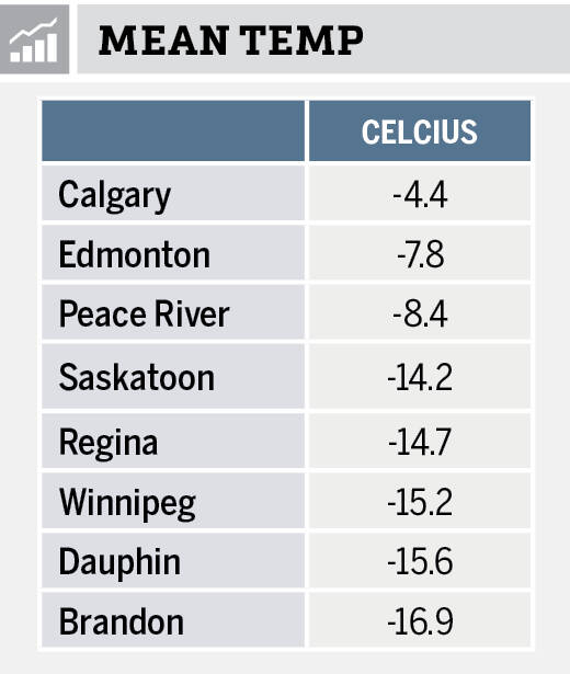
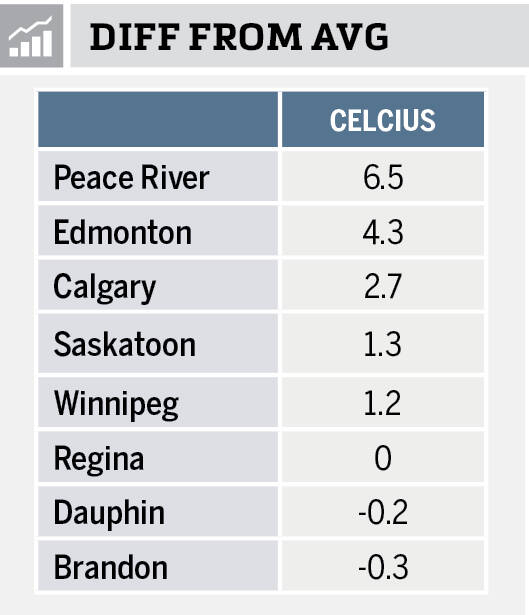
Looking at the data we can see that Alberta had a really warm January with all three stations not only reporting the highest actual temperatures, but also the largest difference from average. Peace River came in at an absolutely remarkable 6.5 degrees above average. The coldest readings, both actual and compared to average, were found in southern Saskatchewan and Manitoba.
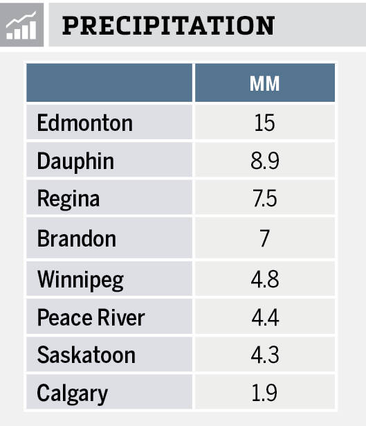
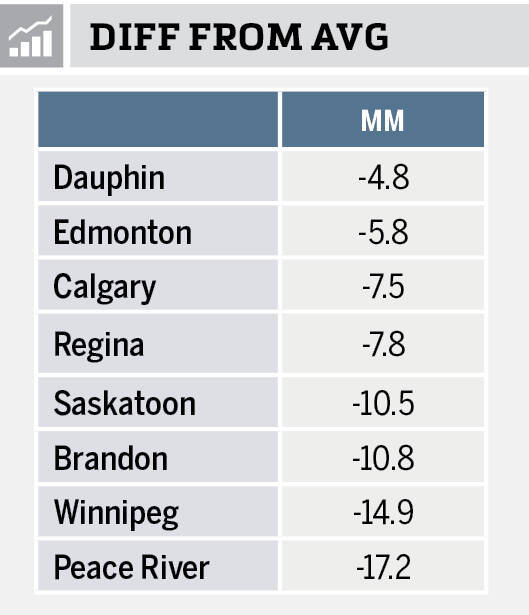
Looking at just the actual amount of precipitation, you might say it was an extremely dry month. January is always one ofthe driest months of the year, so when compared to the average the values do not look that bad. While all regions, or locations, reported below-average precipitation in the month the “wet” spots were southern and central Alberta along with Dauphin in Manitoba. The “dry” spots were Winnipeg and Peace River, which recorded a greater than 14 mm precipitation deficit in the month.
Overall, it was a much warmer and drier than average month across the western Prairies, with south-central regions seeing near average temperatures and below average precipitation. Looking back at the various predictions, there was actually no clear-cut winner. So, with that in mind, here are the latest three-month outlooks.
Starting off as usual with the almanacs, which I think I need to point out have not been doing that great of a job predicting this winter’s weather. The Old Farmer’s Almanac calls for a cold and snowy February and March, followed by a warm April with near-average precipitation. The Canadian Farmers Almanac appears to be calling for February to be a stormy month as they mention a large snowstorm early in the month and then some more stormy weather later in the month, which would indicate above average precipitation. They only mention cold weather once so I will go with near-average temperatures. March sounds like it could be a bit of mixed bag as they call for fair weather, stormy weather, and some cold weather. Overall, I call it near-average for both temperatures and precipitation. Looking at April, they mention fair weather several times but also showers, more showers, thunderstorms and stormy weather. To me that sound like near-average temperatures and above-average precipitation.
Looking at the weather models and starting off with NOAA. This model, again, extrapolating northwards because to them Canada does not exist, appears to be calling for below-average temperatures with above-average precipitation over the western Prairies and near-average amounts over central and eastern regions. With this model it is tough to figure out what is happening over more northern regions.
Next up is my favorite, the CFS model. It is calling for a very cold February across Alberta and Saskatchewan, compared to average, and near- to slightly below-average temperatures in Manitoba. This same pattern is forecasted to continue into March and April but with the anomalies warming to only slightly below-average in Alberta by April with Manitoba seeing slightly above-average temperatures. Precipitation is predicted to be near- to above-average for all three months.
The CanSIPS model is calling for slightly above-average temperatures and precipitation over the eastern Prairies, near-average temperatures and precipitation over the central Prairies, and slightly below-average temperatures and near-average precipitation over far western regions.
Finally, our last weather model, the European or ECMWF. It is predicting below-average temperatures in February across Saskatchewan and Alberta with near-average temperatures in Manitoba. March is looking to see near-average temperatures with April coming in near- to slightly above-average. Their precipitation prediction is for above-average amounts over Alberta in February with near-average amounts in Saskatchewan and Manitoba. March and April are predicted to see near-average amounts right across the Prairies.
Last and definitely least is my throw at the weather dart board. Just like last month, I am still leaning towards the European model, which is similar to the CFS model. As I have always said, if anyone says they can consistently and accurately predict the weather several months ahead, they would be a billionaire.