

With the beginning of a new year comes the usual list of top 10 things about the previous year, and in the category of weather, this really appears to be the case. There are the top 10 Prairie weather stories, top 10 Canadian weather stories, and the top 10 world weather stories, which often tend to be skewed toward U.S. weather stories.
While I will do an article or two about the different top weather stories from across our region and the world, for this article I thought I would take a look at a summary bulletin that was issued by Environment and Climate Change Canada.
Read Also

Forecasting spring 2026 weather on the Prairies
What weather can farmers expect across Manitoba, Alberta and Saskatchewan as they head into seeding? Plus: a lesson on what makes the seasons turn
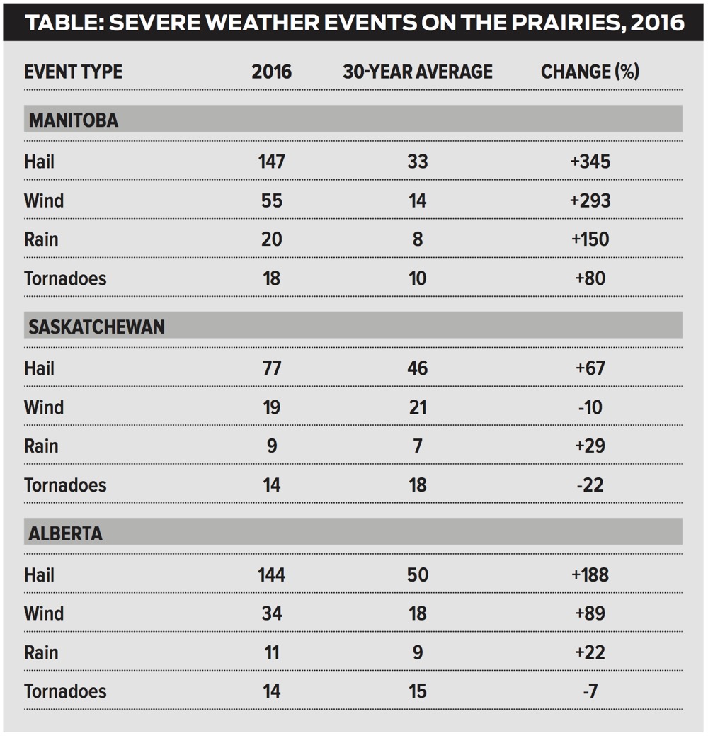
The bulletin was issued in late December and was a summary of severe summer weather across the Prairies. I have to thank the website “A Weather Moment” for capturing this bulletin, as they don’t stick around on Environment Canada’s website for very long. This bulletin is a summary of severe summer weather that is, for the most part, related to thunderstorms, and looks at the occurrence of severe hail, wind, rain and tornadoes and compares what happened in 2016 to the 30-year average. The period of time that was covered by this summary is April to September, and the period of average is from 1980 to 2009.
The definition of “severe weather” from Environment Canada is as follows: A severe thunderstorm event is the occurrence of one or more of: large hail (two centimetres or larger in diameter), heavy rain (50 mm or more within one hour), strong winds (gusts of 90 km/h or greater, which could cause structural wind damage) or a tornado.
2016 was a very active year for severe summer weather across the Prairies, with a total of 595 severe weather reports. This is about a 139 per cent increase over the 30-year average of 249 reports. Manitoba was the most active region, followed by Alberta and then Saskatchewan.
Looking at the bar graph below that breaks out the type of severe weather by province, you can quickly see that severe hail events were by far the most numerous, with 368 total events. This compares to the average of 129 events.

Of particular interest is the fact that Manitoba beat out Alberta. Typically, Alberta sees the greatest number of severe hail events, with an average of 50 events, whereas Manitoba’s average is 33.This is due in part to the high elevation in Alberta that results in shorter distances for the hailstones to fall.This gives the hailstonesless time to melt on the way down, as compared to Manitoba.
Looking at the next category, severe wind events, Manitoba once again came out on top, with 55 events. In fact, Manitoba came out on top for all of the severe weather categories, with Alberta coming in second in three of the categories and tying for second in one. Overall, Manitoba was the only province that saw above-average numbers of severe weather events across all four categories. Alberta saw above-average amounts of all events but tornadoes, while Saskatchewan saw above-average amounts of severe hail and rain events, but was slightly below average in the wind and tornado categories. The tables shown here should help highlight these numbers. Once again, I’d like to thank A Weather Moment for capturing this data.
Next time we’ll begin our look at the top weather events of 2016.


