I know I promised to look at big snowfalls that have occurred in the past, then look at the probabilities of receiving different amounts of snow, but there are a couple of global weather stories that I thought should take precedence. Remember when I reported that, for the first time in a while, the University of Alabama in Huntsville reported a record-warm month? October 2015, it said, was the warmest month ever recorded when compared to average. Well, the U.S. National Oceanic and Atmospheric Administration (NOAA) numbers have now come out and they also report that October set an all-time record for planetary warmth.
Read Also

Prairie weather all starts with the sun
The sun’s radiation comes to us in many forms, some of which are harmful to organic life while others are completely harmless or even essential, Daniel Bezte writes.
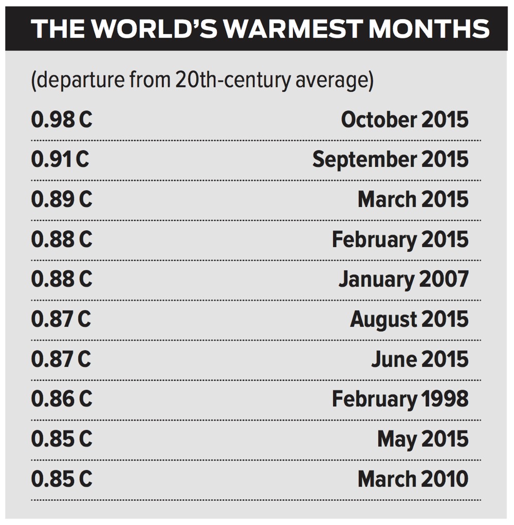
According to NOAA, October’s mean global temperature was 0.98 C above the long-term average. This value comes on the heels of September’s record warmth and was significantly higher than what was recorded in that month. It is pretty much a foregone conclusion that 2015 will beat out last year as the warmest year on record, and with El Niño expected to continue into the early spring of 2016, there’s a good chance that 2016 will beat out 2015. To get an idea of just how warm this year has been globally, check out the table here, which shows the top 10 warmest months globally as departures from the 20th-century average.
As you can see, seven of the top 10 months have happened this year. The question is whether this is just an El Niño-driven warming — or is it a hint of things to come?
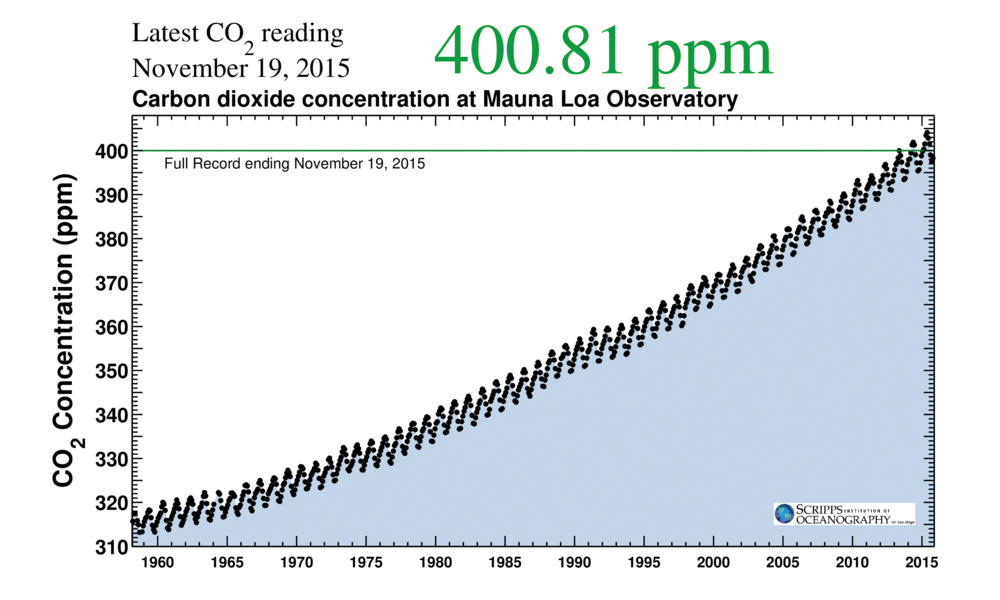
On that note, there was another global weather, or rather atmospheric story that kind of slipped by over the last couple of weeks that partially ties into the warm global temperatures. According to Bob Henson at the Weather Underground, carbon dioxide readings taken at the Mauna Loa Observatory in Hawaii rose above the 400 parts per million (ppm) level on Nov. 12 — and this may mark the last time we’ll ever see a reading below 400 ppm.
Concentrations of CO2 rise and fall during each calendar year, based on the vegetation growth in the Northern Hemisphere, where most of the world’s land mass is located. Atmospheric CO2 concentrations fall during the summer as growing plants take it in, with the lowest concentrations of the year typically occurring in November; CO2 levels then rise during the winter. For those of you who have never followed or seen the long-term trend in global CO2 levels, I’ve included a graph here to help show the steady increase the planet has seen since the 1950s, when levels were first recorded. You can see that in the 1950s, CO2 concentrations were in the 315-ppm range and tend to increase by about five ppm in the winter, then decrease by about the same amount in the summer. Superimposed on top of this yearly increase and decrease is the continual rise in CO2 levels. So, each year the winter high and summer low is about two ppm higher than the previous year.
This year’s minimum was right around 398 ppm, which means that next fall, there is a chance that values might not drop below 400 ppm. While there is no scientific meaning behind 400 ppm — besides being a number higher than any peaks in CO2 levels observed over at least the last 800,000 years — it is a significant psychological value.
Some people argue that Mauna Loa’s values can’t be trusted due to local volcanic activity, but the same overall general trend is found in the data from other sites around the world. For example, data from the South Pole stations have shown a steady increase in CO2 concentrations, which started around 310 ppm in the late 1950s and are currently in the 380- to 385-ppm range.
Next time I promise we’ll take our look at snowfall amounts, unless…