Mix of sun and scattered thundershowers

Issued: Monday, June 22, 2015 – Covering: June 24 – July 1, 2015

This forecast period is starting off much like the last one. The general flow of the atmosphere is fairly zonal, which means a strong west-to-east flow. Sometimes it’s coming a little out of the northwest, which results in slightly cooler conditions, and sometimes it veers a little southwest, which means warmer weather. The trouble is,

Unsettled weather and a look at precipitation across the Prairies

Issued: Monday, June 8, 2015 – Covering: June 10 – June 17, 2015

As we slowly transition into summer, forecasting the weather usually gets easier, but so far not this year. The overall pattern for the next week to 10 days looks like it will continue to be active, with two main low-pressure tracks setting up. The first is to our south, across the northern states; the second


Roller-coaster ride settling into summer weather mode

Issued: Monday, May 25, 2015 – Covering: May 27 – June 3, 2015

You have to love spring across the Prairies. One day it’s cold and snowy and a few days later it feels like summer! It looks like our spring roller-coaster ride is going to continue, but it does appear the ride is coming to an end. After a beautiful weekend and first half of the week,

How are severe thunderstorms created?

All the ingredients can be in place, but good luck pinpointing where the storm will form

I’d said we were going to examine which weather conditions bring long-duration rainfall warnings, and also dig into some of the rainfall records from across southern and central Manitoba in this issue, but that topic will have to wait until next time. An early deadline for this issue due to the long weekend, combined with


Nice spring weather ahead

Issued: Monday, April 6, 2015 – Covering: April 8 – April 15, 2015
Arctic high pressure built into our region last weekend and into the early part of this week as expected, but what wasn’t expected was the strength and resultant cold air. Luckily, this arctic high will pull off to the east by the middle of this week, allowing milder air to move in again. Several large

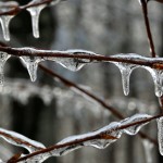
Small Icicles Hanging From a Branch

Cold, wet spring for 2015

If forecasters have it right, this winter could be another long one, 
but it won’t see long periods of below-normal temperatures
Call it an intermission from winter if you will, but don’t expect the warmer-than-usual temperatures to last — at least not in Manitoba. Speaking at Farm Credit Canada’s Ag Outlook in Winnipeg last week, meteorologist Mark Robinson said that this year’s El Niño is a weak one. “Right across the country we’re seeing warmer-than-normal temperatures,”


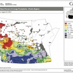
This map shows the total amount of precipitation that has fallen across the Prairies during the 30 days ending Aug. 25, as a percentage of the average expected for this period. This map seems to be a continuation of the maps we’ve seen so far this summer, with above-average amounts of rain over southern Alberta, Saskatchewan and western Manitoba and below-average amounts over northern Alberta.

Late summer/early fall weather

Issued: Monday, September 1, 2014 · Covering: September 3 – September 10, 2014
Last week’s weather ended up following its own rules as a relatively fast-flowing pattern developed across our region, bringing with it rapidly changing weather conditions. For this forecast period it looks like this weather pattern will persist. High pressure that started off this week will quickly be replaced by an area of low pressure that

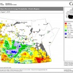
This map shows the total amount of precipitation that has fallen across the Prairies compared to historical averages over the 30 days ending Aug. 7. You can see just how dry it’s been across nearly all of agricultural Manitoba during this period; the only wet area was around The Pas. Farther west, much of northern and western Saskatchewan was wetter than average, as was east-central Alberta.

Off to a warm and dry start

Forecast issued Aug. 11, 2014, covering the period from Aug. 13 to 20, 2014
Only problem with last week’s forecast was that we saw two cold fronts move through last weekend instead of just one. The first moved through Saturday, bringing a few quick-moving thunderstorms. The second moved through on Sunday, bringing scattered clouds, the odd shower and cooler temperatures. Hopefully the forecast for this week will be as


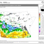
This map shows the total amount of precipitation that fell across the Prairies during the 30 days ending July 31 — only one day shy of the monthly total. Most of agricultural Manitoba was fairly dry during this period, with most areas seeing less than 40 mm. Extreme southeastern and northwestern areas were a little wetter. The wettest parts of the Prairies were over northern agricultural Saskatchewan and northeastern Alberta, especially around Edmonton, where an upper low brought large amounts of rain.

High pressure and plenty of sunshine

Forecast issued Aug. 4, 2014, covering the period from Aug. 6 to 13, 2014
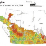
Last week’s forecast worked out pretty much as expected. The weak system anticipated to move through late in the weekend was a little quicker than expected and as a result, less cool air was pulled in behind the system. This gave us warmer weather over the last part of the long weekend. This forecast period

Weather map – Western Canada

Here comes another upper low

Covering: June 18 – June 25, 2014

In summer, the one weather feature I don’t like to see is an upper low. They usually mean cloudy, cool, wet weather, which can last for days. So far this month we’ve seen two different upper lows move through and it looks like we might be in for another. Last weekend we saw a fairly