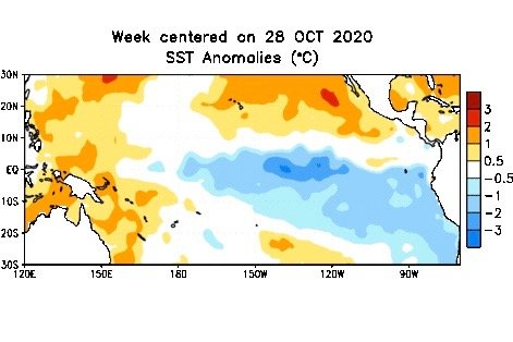
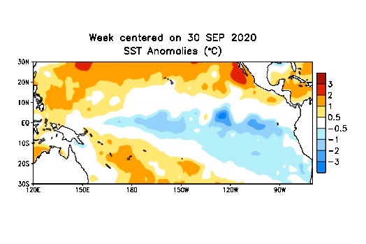
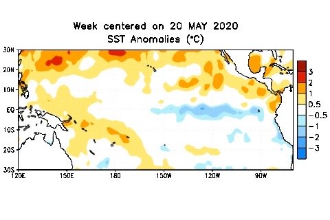
La Nina winters have a slightly higher-than-average chance of being cooler and wetter than average.

La Nina and the winter forecasts

Canada’s CanSIPS model still calls for a warmer-than-average October

Icannot believe another month has come and gone. Sometimes it seems like it was the longest month ever and other times it felt like one of the fastest. September’s weather kind of mirrored my feelings. Sometimes it seemed like fall was here to stay and at other times summer tried to make a comeback. The question is whether

A surfer walks into the Pacific Ocean at Hermosa Beach near Los Angeles on Sept. 4, the first day of a record heat wave in the area.

The Pacific Ocean’s impact on our weather

In a La Niña event, sea surface temperatures cool down in spots that are usually warm

In the last issue, I pointed out that La Niña conditions have developed across the Pacific Ocean and these conditions have sustained themselves for three months, meaning we are now into a La Niña period which is forecast to last through most, if not all, of the winter. Before we look to see how this


Sea surface temperature (SST) anomalies over the southern Pacific for the week centred on Sept, 30, 2020. (CPC.ncep.noaa.gov)

La Nina to bring colder, drier winter

MarketsFarm — There’s a La Nina poised to exert influence on the coming North American winter, according to Drew Lerner, senior agricultural meteorologist for World Weather Inc. in Kansas. A La Nina generates colder-than-normal temperatures, as opposed to the warm temperatures garnered from an El Nino. Both weather phenomenon can be found over the Pacific

Average sea surface temperature anomalies over the equatorial Pacific Ocean for the week centred on Sept. 2, 2020 compared to 1981-2010 base period. (CPC.ncep.noaa.gov)

La Nina present, 75 per cent chance seen through 2020 winter

Reuters — La Nina conditions were present in August, and have a 75 per cent chance of continuing through the Northern Hemisphere winter of 2020-21, a U.S. government weather forecaster said on Thursday. The La Nina pattern is characterized by unusually cold temperatures in the equatorial Pacific Ocean. A borderline moderate La Nina event is


Sea surface temperature anomalies on the tropical Pacific Ocean for the week centred on May 20, 2020. (CPC.ncep.noaa.gov)

El Nino, La Nina patterns not seen prevailing during summer

London | Reuters — Sea surface temperatures in the tropical Pacific remain neutral, meaning that neither El Niño nor La Niña weather patterns are prevailing, the U.N. World Meteorological Organisation said on Thursday. The El Niño pattern brings a warming of ocean surface temperatures in the eastern and central Pacific every few years, and is


El Nino seen transitioning to neutral in next month or two

El Nino seen transitioning to neutral in next month or two

Reuters — The El Nino weather pattern is likely to transition into ENSO-neutral conditions in the next month or two, a U.S. government weather forecaster said on Thursday. “ENSO-neutral” refers to periods in which neither El Nino nor La Nina is present, according to the National Weather Service’s Climate Prediction Center (CPC). ENSO-neutral conditions are


Averaged global sea surface temperature anomalies (in degrees Celsius) for the week centred on May 2, 2018. (NOAA Climate Prediction Center graphic)

El Nino pattern could emerge by 2018-19 winter

Reuters — The El Nino weather pattern, associated with warmer and wetter weather than usual that may give rise to damaging conditions, could emerge by the 2018-19 Northern Hemisphere winter, with neutral conditions expected to prevail through November this year, a U.S. government weather forecaster said on Thursday. The last El Nino, a warming of

Environment Canada on April 30 released this forecast map for the probability of above-normal precipitation for the period of May through July 2018.

May showers likely to leave growers unsatisfied

CNS Canada — Canada’s Prairies can expect to see regular rainfall in most regions during May, but it likely won’t be enough to offset dry conditions recorded over the past several months. According to Drew Lerner of World Weather Inc. in Kansas City, the first half of May should see average rainfall amounts in most