As rain events persist in Manitoba, it’s hard to believe that a few months ago everyone was worried about lack of moisture.
“We had an extremely warm winter with lower than normal precipitation in most areas,” said Trevor Hadwen, agroclimate specialist for Agriculture and Agri-Food Canada. “We were a little worried going into the spring, for sure. But this has calmed us down.”
Why it matters: April and May rain across most of the Prairies has helped recharge groundwater levels.
Read Also

Student agronomy challenge coming to Assiniboine College
The Prairies’ first agronomy competition brings together post-secondary ag students for hands-on crop advising challenges at Assiniboine College in Brandon, Man.
In Manitoba, a major storm system May 24 dropped up to 86 millimetres of rain in central Manitoba, while areas of the west were buried in up to 25 cm of snow. The timing was unfortunate for soybean growers facing insurance seeding deadlines, but it and other rain events also dampened fears of another drought year.
At the end of the second week of June, about 92 per cent of Manitoba’s acres were planted. Prairie-wide, most producers have sufficient topsoil moisture to get crops off to a decent start. Now they’re waiting for summer heat.
Wet Manitoba
Manitoba received the most precipitation among the Prairie provinces this spring. Regions from Winnipeg to Brandon, for example, have averaged around 200 mm of moisture, Hadwen said.
In comparison, Saskatchewan received just over 100 mm around Regina at the drier end of the spectrum, to a maximum of about 150 mm west of Saskatoon. Most of Alberta ranges from 100-125 mm.
That’s a return to normal. Manitoba typically has a wetter climate, Hadwen noted. Recent years when parts of Manitoba suffered significant moisture deficits are an aberration.
“Last year, we had some very dry conditions compared to what we would normally get,” he said, adding that timely rains and cooler temperatures helped ease the strain.
“This year, that 200 millimetres for that central southern portion of the province is really good for soil moisture; probably a little too much for some areas,” he said. “That is starting to percolate and really recharge those subsoils.”
Manitoba conditions don’t spark major concern for the meteorologist. The province has pretty much recovered from the spate of drought years that stunted crops and led livestock producers to destock herds.
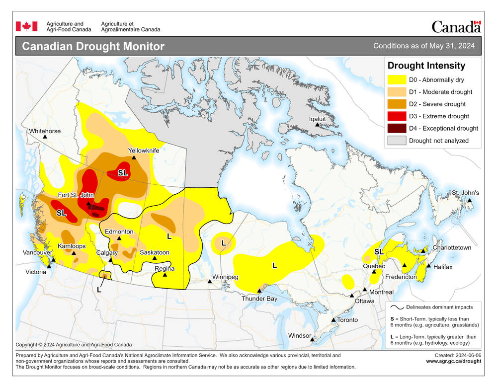
The northwest remains the only area of worry. The region has received less precipitation. Parts of western and northern Manitoba were the only areas of note when the Canadian Drought Monitor released its updated map at the start of June.
More storms?
There’s one major downside: Manitoba likely faces increased risk of severe storms. Additional moisture, combined with forecasts of a hot summer, are all the ingredients for an active severe weather season.
“One of the key components of getting storm events is moisture,” said Hadwen. “If we have moisture available on the surface and we get some heat, that will breed thunderstorm activity.”
Manitoba’s not alone in that risk. While less rain has fallen in Alberta and Saskatchewan, those provinces have still received significant moisture, and Environment and Climate Change Canada predicts a hot summer across the Prairies.
The eastern Prairies, however, are expected to be even hotter than the west, further increasing the risk for Manitoba.
“We will likely get larger and more storm events than we have had in the last number of years, but we’ve been really low in terms of the number of hail events and the number of significant storm events,” said Hadwen.
There is also a difference in rainfall timing.
“During the last couple of years, we’ve had these big rainfall events in one or two days, then dry for three weeks, and then another big event,” said Hadwen. “This year, we’re getting continuous rain for two or three days, then two days of nice weather, and then two more days of rain.”
These “more organized” rain systems are a result of the jet stream moving southward.
“Last year, the jet stream was, for the most part, pushed further north and we weren’t getting those organized rainfall systems that we’ve got this spring.”
From an agricultural perspective, that’s been beneficial.
Saskatchewan and Alberta
The Canadian Drought Monitor still reported patches of Saskatchewan and Alberta in severe drought or worse as of June 1, but it’s not the crisis of a few months ago. There’s been “tremendous improvement” in much of the western Prairies, Hadwen noted.
In fact, the prognosis for Saskatchewan is almost as good as that for Manitoba, with only a small pocket of the northwest with any significant drought risk.
In Alberta, the Peace River region in particular has missed the rains that eased circumstances elsewhere. Hadwen noted that region typically gets most of its rain in late June and early July.
Subsoil moisture is still lacking in both provinces.
“We have the moisture in that top root zone that will really get us through that spring period, but we really need moisture to percolate down and recharge levels further down,” said Hadwen.
He said precipitation models don’t revealing much for the coming months, but there is reason for optimism now that rain has started to fall.
“It’s a cyclical thing. You need that moisture that we’ve received to break the drought. So, now that we’ve got the moisture in the system, we will continue to get some big rainfall events until that moisture dries out.”
Not out of the woods
While the yearly outlook is much improved, Hadwen cautioned that there is still a significant moisture deficit in the larger three-to-five-year analysis.
“We’re not quite out of the woods in some parts of the Prairie region. The rain is going to solve the immediate moisture needs, but it still takes a long time for the pastures to fully recover, and it also takes a long time for water supplies and groundwater to fully recover.”