
The Manitoba Forage and Grassland Association envisions farmers using its Aquanty water forecasting app as commonly as they would look at their local weather forecast.
“There’s a real opportunity for some water conservation at the farmgate level that this tool enhances,” said MFGA executive director Duncan Morrison.
Why it matters: Understanding where water is and where it’s going on a farm can be helpful for planning and risk management.
Read Also
Malta bee exporter blasts criticism from Canadian beekeepers
A honeybee exporting firm on the Mediterranean island of Malta says they’re collateral damage to a dust-up in the Canadian honey sector over imports of replacement bees.
The forecasting tool is the latest phase of the Aquanty project, one of the MFGA’s major undertakings.
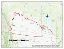
The producer group began working with Ontario-based hydrologic modelling firm Aquanty Inc. in 2015, with financial help from Agriculture and Agri-Food Canada. The initial goal was to develop a 3D model of the Assiniboine River basin, broken down into five interconnected models encompassing everything from the overall basin to a micro-analysis of the Assiniboine-Birdtail Watershed.
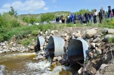
Since completion in 2018, the model has been put to work in local flood and drought planning. One study in the Oak River-Shoal Lake Watershed looked at how forages, grasslands and wetlands influenced flood and drought mitigation between 2009 and 2016.
In another case, those involved in the Assiniboine River Basin Initiative wanted to know how certain water retention projects along the eastern Souris River might impact flows in the region. Another study looked at flood risk management around Virden.
In June 2021, a second round of federal funding was announced for the second phase of the project. This time, the goal was to develop a forecasting tool for farmers. It would use computer models to simulate how water cycles through the natural environment and how it would behave in real areas in real weather years.
In 2022, the MFGA expanded the model to include the Pembina River basin and the tool was released to the public in March.
“Ultimately, what we’ll want to do is simulate the real world in a digital model,” said Aquanty Inc. senior scientist Steven Frey, speaking at the MFGA Regenerative Ag Conference in Brandon Nov. 15.
To do that, the model incorporates a wide scope of data, including current weather forecasts, historical weather data, snow cover and melt rates, soil moisture and groundwater levels drawn from a network of sensors and years of field-level crop inventory numbers.
Parameters are then set within the digital model to reflect how water moves across the landscape and through the subsurface.
“When all of that data is fed into a model, we can run the model in real time in order to produce a forecast,” said Frey.
Ag impacts
The software’s ability to dynamically couple groundwater to surface water simulations will be of particular interest to agriculture.
Frey used the example of irrigation. The tool will allow the end-user to see if their local aquifer is recharging and allow them to make informed decisions about their farm water management.
“There are parts of the world where irrigation has gone wrong and groundwater has been pumped at an unsustainable rate in order to support agricultural production,” said Frey.
“If we don’t adequately account for irrigation impacts on the groundwater supply and the ability of the natural climate to replenish the groundwater between irrigation seasons, we run into a situation where we’re basically mining groundwater to support agriculture.”
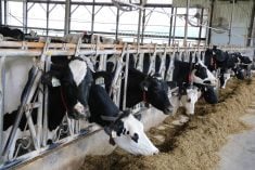
He also cited potential benefits for livestock operations.
“We’re producing surface water forecasts, surface water depth forecasts and groundwater forecasts in real time. So, if you’re running livestock out on pasture and you’re relying on a dugout or shallow wells for water supply, you can go in and find your areas of interest, click on them, and get an idea of where the surface water levels, groundwater levels, and even soil moisture levels are going over the course of seven days or 30 days.”
This information could give the producer advance warning if they need to plan for an alternative water supply.
Morrison said scenarios like that are the tip of the iceberg.
“It’s the ultimate decision support tool,” he said. “It’s a planning tool for farmers. It’s an investment tool for conservation groups. It’s a risk management tool for municipalities and it has government application across all of those.”
While he feels the tool has wide applications across rural governments and organizations, the MFGA’s priority is how it can be used by farmers.
Accessing the tool
Producers can get free access to the model through a portal on the MFGA’s website. The association has also offered in-person tutorials for farmers.
“There is no charge at this time. We’re basically just leaving it open on our own good graces here so that as many [as possible] can learn about it at their convenience,” said Morrison.
The organization hasn’t tracked how many farmers have visited the portal, but Morrison said he feels there has been a lot of interest.
At some point the association does plan to levy a charge for the tool, he advised.
“We don’t have the capacity to keep it open forever. We haven’t got a shutdown date yet, but we’d really like to package it up and get some financial consideration for it.”
The MFGA is planning a “brainstorming tour” of agricultural groups they hope will lend their weight to the tool. The hope is to get larger sponsorship than it would by going farmer to farmer, Morrison said.
“It’s like we’re living in a pup tent and owning a Porsche. We’re very humble; we’re very nimble, but we have this wonderful tool that we need to drive.”