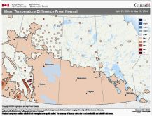
As we begin to transition from fall to winter the weather can often behave unexpectedly, and we definitely saw this happen last week. Around this time last week the forecast called for a fairly strong area of low pressure to move northward out of the States, then move off to the northeast. Well, this low did track as expected, but then the system stalled and deepened significantly over northwestern Ontario, which ended up changing the whole pattern of weather across much of Canada and the northern states.
This forecast period begins with us still dealing with the large low wobbling over northwestern Ontario. We will see partly cloudy days along with northwesterly winds as we remain on the back side of the low. This will keep temperatures on the cool side, with highs expected to be around 10 C. Overnight lows will be a little trickier and will depend on cloud cover. If skies are clear at night, we’ll see lows in the -2 C range; otherwise, lows will be around +3 C. This low looks as if it will weaken and finally move off to the east by about Friday.
Read Also

Canadian canola prices hinge on rain forecast
Canola markets took a good hit during the week ending July 11, 2025, on the thought that the Canadian crop will yield well despite dry weather.
Over the Thanksgiving long weekend, the weather models show a ridge of high pressure building to our southeast and extending back into the southern Prairies. This should bring mainly sunny skies along with slightly warmer temperatures, and highs expected to be in the 10 to 15 C range. A large area of low pressure is also forecast to begin moving in off of the Pacific sometime on Sunday. This likely means we’ll see increasing clouds with the chance of showers on Monday. A southerly flow ahead of this system could also mean we’ll see fairly mild temperatures Monday, but that will depend on the timing and amount of cloud cover and any precipitation.
Looking further ahead, the models show this low deepening and stalling out to our east, meaning a return to cool unsettled weather.
Usual temperature range for this period: Highs, 8 to 17 C; lows, -4 to 5 C.