Idon’t want to get too excited yet but the weather pattern forecast over the next couple of weeks looks to be shifting away from the pattern we have been stuck with for the last several months.
To start with, it looks like high pressure will dominate our weather for much of this week and well into the long weekend. Under this ridge of high pressure we should continue to see sunny skies with temperatures pushing the high end of the usual temperature range for this time of the year.
Read Also

VIDEO: What climate change data gets wrong about the Prairies
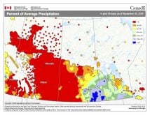
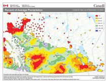
Precipitation, not temperature, may be a better gauge of climate change impact on the Prairies, says director of the Prairie Adaptation Research Collaborative.
The only storm system we will have to watch out for is an area of low pressure forecast to begin developing to our northwest early this week. This low is then forecast to begin pushing eastward next Saturday or Sunday. This low will be the test as to whether we break out of our current weather pattern.
Some of the weather models are showing this low affecting southern and central Manitoba sometime on Sunday or Monday. They then show the low stalling out over our region, bringing showers and cool weather for the first half of next week. If this scenario plays out, then it would appear that our weather pattern has not changed.
The other models are calling for most of the energy from this low to move through northern regions, bringing only the chance of some showers or thunderstorms to southern and central regions late Sunday or on Monday. This would then be followed by a fairly quick return to mild temperatures by Tuesday or Wednesday of next week. This would be a break from what we have been experiencing all summer and may be a sign of what is to come.
Usual temperature range for this period: Highs: 16 to 25C. Lows: 4 to 13C.