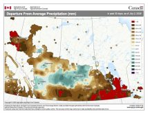
While the weather models were able to predict the fairly active weather pattern that brought several rounds of showers, thundershowers and just general light rains over the last week or two, they did struggle with the timing of the systems and the temperatures.
It looks like this forecast period is going to continue on the active side. The weather models show an area of low pressure tracking across the Dakotas on Monday and Tuesday. This system will push an area of showers into southern regions on Monday, expanding northward into the Interlake on Tuesday. The cloud cover and showers will keep temperatures on the cool side, with daytime highs forecast to be around 15 C and overnight lows in the 6 to 9 C range. High pressure is then forecast to briefly build in around mid-week, bringing sunshine along with slightly milder temperatures.
Read Also

Thunderstorms and straight-line winds
Straight-line winds in thunderstorms can cause as much damage as a tornado and are next on our weather school list exploring how and why severe summer weather forms.
Late next week, the weather models show a second area of low pressure developing to our southwest, then tracking northeastward across southern Manitoba. Expect increasing clouds on Thursday, with showers and thundershowers moving in later in the day and lasting into Friday. Even with the cloud cover and showers, temperatures look to be mild, with daytime highs right around 20 C.
Weak high pressure is then forecast to build in over the weekend and into the early part of next week. This high should bring sunny to partly cloudy skies with daytime highs forecast to be in the upper teens to low 20s and overnight lows around 6 C.
Looking further ahead, the weather models show an area of low pressure cutting across northern Manitoba around the middle of next week. While this low doesn’t look like it will impact us directly, the models show a strong area of arctic high pressure building southward behind the low. Confidence in this happening is fairly low, but if it does materialize, we can expect the first widespread fall frost by Thursday or Friday, which would be right around the same time as we saw our first fall frost last year.
Usual temperature range for this period: Highs, 13 to 24 C; lows, 3 to 11 C.


