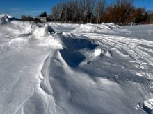
After a month of back-and-forth temperatures in January that eventually worked out to above-average monthly temperatures, February turned out to be… well, just darned cold.
The nice warm temperatures that moved in over the last five days of the month were not enough to overcome the persistent cold weather that dominated the majority of the month. The first two weeks of February saw daytime highs struggle to make it above -15 C with overnight lows falling on most nights into the -25 to -30 C range. We did see a short mild spell around the middle of the month before more cold weather moved back in during the third week. Even after adding in the mild end to the month, it was not nearly enough to overcome the cold start, with all three regions recording well-below-average temperatures for the month. Mean monthly temperatures averaged about 3° below the long-term average across all three regions, making it the coldest February since 2015, which isn’t that long ago; it’s just that we seem to be getting used to warm Februarys.
Read Also

June brings drought relief to western Prairies
Farmers on the Canadian Prairies saw more rain in June than they did earlier in the 2025 growing season
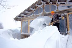
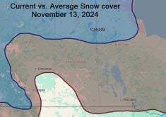
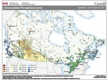
Precipitation was pretty scarce during February, with most of the southern and central regions seeing amounts that were well below average for the month. Both the Winnipeg and Dauphin regions were the dry spots, with less then three mm of water-equivalent precipitation recorded. Far eastern regions, along with northwestern regions, saw values a little closer to average; in fact, a few areas actually saw near- to slightly above-average amounts.
Who called it?
Overall, February was a cold, dry month across our region. Looking back at the forecasts for the month, it appears only one of the forecasts was right on the money. For the first time in a while, my forecast was the only one that was correct, with a prediction of a cold and dry February.
Now, on to the March and April forecasts. According to Environment Canada’s probabilistic and deterministic forecast it looks like March will see near- to slightly above-average temperatures, with a trend to below-average temperature late in the month and into April. Precipitation, according to E.C., will continue to be near to below average over the next two months. The Climate Forecast System model over the next six weeks calls for above-average temperatures for March, trending toward below-average temperatures in April. Precipitation is forecast to be near to slightly above average.
Moving on to the two almanacs: the Old Farmer’s Almanac calls for a warm and dry March followed by a slightly colder-than-average April, but with well-above average amounts of precipitation. The Canadian Farmers’ Almanac seems to call for near-average temperatures for March, with wetter-than-average conditions as it mentions stormy and unsettled conditions several times. April looks like it will see near- to above-average temperatures along with near- to below-average precipitation as it mentions fair and pleasant weather several times, with no mention of any big storm systems.
The U.S. National Oceanic and Atmospheric Administration’s forecast calls for near-average temperatures over the next two months, along with slightly above-average precipitation. Last but not least, my forecast, which is based on all of these forecasts plus my own gut feeling, leans toward a warmer-than-average first half of March followed by near-average temperatures during the second half of the month. If we don’t see any significant snowfall over the next couple of weeks, the chances of warmer-than-average temperatures for all of March go up. This is due to the lack of snow cover, which means a quick melt resulting in plenty of open ground to help warm the air. April is a tough one to figure out; if we continue to see below-average amounts of precipitation over the next month, I think April will see above-average temperatures as well. As for precipitation, your guess is as good as mine for April. My gut leans toward wetter than average, but my head can’t see a reason for the current drought conditions to break. Could be an interesting month!
Ontario’s rainfall
Since I still have a little bit of room left for this week, I figured it’s time to hit on a few big weather stories from the last couple of weeks. First was the record-breaking heat and precipitation event that hit eastern North America in mid-February. A record-breaking ridge of high pressure over the East Coast helped to pump up record-breaking temperatures along with record-breaking amounts of atmospheric moisture across a large portion of eastern North America last week. Temperatures soared, breaking several all-time recorded highs for February. The record atmospheric moisture pumped up against the cold high pressure over our region, resulting in some of the heaviest rainfalls ever recorded in February across a large portion of Michigan and southern Ontario.
Finally, the latest global sea ice amounts just came in, and according to the National Snow and Ice Data Center, “January of 2018 began and ended with satellite-era record lows in Arctic sea ice extent, resulting in a new record low for the month. Combined with low ice extent in the Antarctic, global sea ice extent is also at a record low.” Feels like I should say something, but I will let the facts stand for themselves.