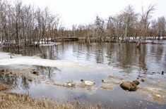
Once only known to locals as a former destination for some whooping and hollering, this oxbow is now a national icon as the place where flood fighters tried something never done before in this province.
Choosing this site for a deliberate breach makes sense despite the protests of local farmers that it will affect highly productive farmland instead of pastures farther downstream, says Steve Topping, Manitoba Water Stewardship’s executive director of regulatory and operational services. The river has spilled its banks there before. The last time was 1955 because of an ice jam, he said.
Read Also
What is perfect Christmas weather?
What is ‘perfect’ Christmas weather on the Prairies? Here’s where you should head this holiday, according to historical weather data.
The weir was built on PR 331 so there’s good road access, a stable foundation and the road will minimize the erosion.
The release site is in an oxbow, sheltered from the main part of the river and its current, making it easier to manage the water.
“I also want to point out the controlled release needs to be as close as it can be to Portage la Prairie because we cannot carry water farther down the Assiniboine River to a release point,” he said. “The dike can’t handle that capacity.”
Water from the controlled spill started as a trickle early May 14 building up to 500 cfs. It was to peak at 3,000, Topping said. Because the water was being released slowly it was expected to take seven to eight days to reach the eastern side of the projected spill zone.
Officials refer to it as the “waffle effect” – mile roads slow the water like waffle cells hold syrup.
Homes in the communities of Starbuck, Sanford and La Salle are not expected to be affected by the spill, Chuck Sanderson, executive director of Manitoba Emergency Measures Organization, said May 12 during a briefing, although he suggested flood protection for homes in those towns along the La Salle River should beef up their flood protection.
Elie could see water at its south end as water backs up the Elm Creek Channel.
Once alerted, homeowners in the flood zone rushed to erect sandbag dikes, but didn’t know how high to build them and initially some had difficulty getting sandbags.
Crews were busy last week surveying the area. Ashton said dike elevations will be delivered in person to residents in the days ahead along with any other information the province has.
People were also upset the controlled release was postponed several times. But Ashton defended it saying the extensions allowed more time for flood protection.
Both Ashton and Topping said they are confident the release of water can be controlled. Rip rap rock protects the weir from erosion. The site is monitored 24 hours a day and heavy equipment is there to adjust the flow, or even stop it, if necessary.
Topping said he doesn’t know how long farmland in the spill zone will be under water.
“There will be some areas that will have trapped water (after the water recedes),” he said. “We need to address those immediately with equipment or with pumping so agricultural producers can get on the land as soon as possible.” [email protected]