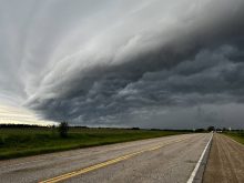
After getting almost a week of what felt like summer weather, it looks like we are returning back to the same old pattern that has been controlling our weather for what seems like forever.
Here is the way the pattern is shaping up. There is a persistent area of low pressure over northeastern North America with a ridge of high pressure over far western North America. This places us in between the two main systems. The flow of the atmosphere is to go over the western ridge, then dive southeastwards and loop under the eastern low. This is keeping us in an active pattern as the eastern low wobbles and drifts back and forth. For this forecast period, it looks like the low will wobble westwards which means cooler temperatures and plenty of chances for clouds, showers, and thunderstorms.
Read Also

VIDEO: What climate change data gets wrong about the Prairies
Precipitation, not temperature, may be a better gauge of climate change impact on the Prairies, says director of the Prairie Adaptation Research Collaborative.
The cool-unsettled weather looks like it will last right through the weekend before high pressure begins to build in from the north. Under this area of high pressure we will see a nice sunny start to next week with slowly warming temperatures under the strong midsummer sun.
The models then show summer heat building in for the second half of next week with highs in the upper 20s to low 30s in the forecast. Once again though, I will have to see it to believe it.
Usual temperature range for this period: Highs: 21 to 31C Lows: 9 to 16C