


When will spring get here? When will the melt start? Those are the questions I’ve heard most in recent days. Thanks to a series of arctic highs, it looks like spring, or the melt, will not move in until early April.
We saw the impact of these arctic highs in the last forecast period. For the most part, they have kept the southern North American storm track just to our south, in North Dakota. This means we have missed most of the snow and accompanying moisture and have stayed on the cool side.
Read Also
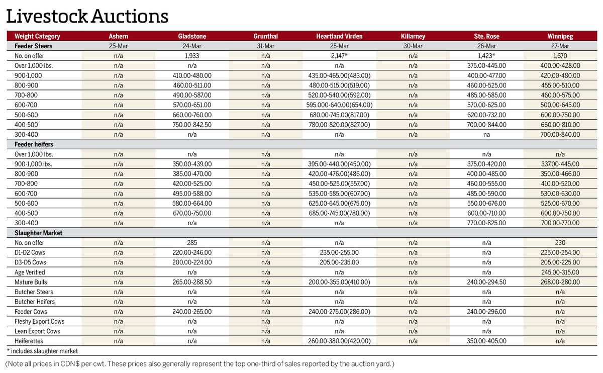
Manitoba cattle prices April 1
Here’s what cattle were selling for in Manitoba from March 24-31, 2026. Four of the seven main livestock auction marts held sales.
Interestingly, while it has been cool, it has not been bone-chilling cold, despite a pattern that should bring us very cold weather.
For this forecast period, it looks like we will see the same overall weather pattern stay in place. Arctic high pressure that brought plenty of sunshine over the weekend should move to our east, allowing milder air to work into our region on the backside of the high.
Typical with early spring, the weather models show a strong storm system developing to our southwest and moving northeastward on Thursday and Friday.
At the same time, weather models show another arctic high dropping southward. It looks like the arctic high will win out, keeping the storm in the Dakotas, but as usual, we need to keep an eye on this system.
Behind this storm system, arctic high pressure will drop in over the weekend, bringing a return to sunny skies, light winds and cold temperatures. Expect temperatures to be around the bottom end of the usual range for this time of the year.
As the high slides to our south and east early in the last week of March, we will see the flow become westerly to southwesterly, which should allow temperatures to rise toward more average values.
Looking further ahead, there is still no strong sign of change in the overall weather pattern, so it looks like spring won’t make much of an appearance until April.
Usual temperature range for this period: highs, -7 to +5 C; lows, -19 to -7 C.


