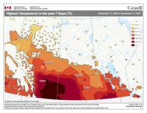
Last issue’s forecast turned out not too badly, with only a couple of wrinkles. There was a faster than expected return to mild temperatures and instead of a southern low, the western ridge rebounded, bringing nice warm fall weather through the last weekend of October.
As we head into November, we will see average daytime highs drop toward the freezing mark and the sun’s energy will become pretty weak, which means we must keep our eyes on storm systems that have potential to usher in the start of winter.
None of the medium-range weather models show a strong chance of winter beginning, but we all know how quickly things can change at this time of the year.
Read Also
The lowdown on winter storms on the Prairies
It takes more than just a trough of low pressure to develop an Alberta Clipper or Colorado Low, which are the biggest winter storms in Manitoba. It also takes humidity, temperature changes and a host of other variables coming into play.
It looks like this forecast period will start off seasonably mild as a trough of low pressure digs southward to our west. The counter-clockwise flow around the trough will pull mild air northward, pushing daytime highs into the 5 to 7 C range on Thursday and Friday.
Then, fall-time uncertainty works its way into the forecast in the form of an area of low-pressure ejecting northeastward out of the western trough late in the week or over the weekend. There is little consensus on the track of this low, but there is a chance it could track through our region, bringing with it some accumulating snow.
Fortunately, at least for those of us who are not ready for winter, it looks like we will see one more push of mild air begin the week of Nov. 7. Expect daytime highs to be around 5 C, with overnight lows falling to around -4. Cooler air is then expected to drop southward around mid-week, but there are no signs of an early season outbreak of cold air.
Usual temperature range for this period: highs: -2 to 10 C; lows: -11 to 1 C. Probability of precipitation falling as snow: 60 per cent.


