After a warm September across the Prairies, the first half of October continued in September’s footsteps. Above-average temperatures graced all three Prairie provinces for the first two to almost three weeks of the month. There was not much precipitation, making for absolutely beautiful fall weather.
The wheels didn’t quite fall off, but winter made an early appearance during the last six to nine days of the month and we saw those well-above-average temperatures turn to well-below-average. Worse, Mother Nature decided to throw in some snow. While not unheard of, it was early for winter to move in.
A warm start to spring resulted in some very early dates for the last spring frost, and a warm first half of fall made for some late first fall frosts. This resulted in a remarkably long frost-free season.
Read Also

VIDEO: What climate change data gets wrong about the Prairies
Precipitation, not temperature, may be a better gauge of climate change impact on the Prairies, says director of the Prairie Adaptation Research Collaborative.
The table below shows the date of the last spring frost, first fall frost and length of the frost-free season for the major sites I use across the three Prairie provinces.
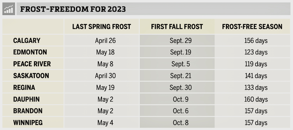
All the locations’ frost-free seasons were much longer than average. While I don’t have all the data for the longest frost-free seasons, the 156 days in Calgary, thanks to a very early last spring frost, is well beyond the average of about 115 days and is likely in record territory.
The numbers from Saskatchewan are also impressive but not likely to be records. In Manitoba, all three sites had extremely long frost-free seasons and I know Winnipeg tied its record for longest season set in 1960.
Let’s look at how October’s weather numbers added up. In Alberta, despite extreme cold during the last week of the month when temperatures dipped into the -20 C range on a few nights, the average monthly temperatures were near average.
Mean monthly temperatures ranged from 5 C in Calgary, which was bang on average, to 3.6 C in Peace River, which was about 0.8 C above average. Precipitation was well below average in both the Edmonton and Peace River regions and above average in and around Calgary, thanks to a shot of heavy snow late in the month.
Across Saskatchewan, the same pattern played out. Both Regina and Saskatoon reported mean monthly temperatures around 4.1 C, about average for both locations. Precipitation was below average around Regina, with about 15 mm reported, compared to the long-term average of 25 mm. Saskatoon reported around 20 mm of water-equivalent precipitation, near to slightly above average for that location.
Manitoba was the prairie hot spot in October, as it was the last to see the cold air. All three locations reported mean monthly temperatures either right around or above average for the month.
Brandon was the cold spot with a mean monthly temperature of 4.3 C, which was 0.2 C above average. Dauphin reported a temperature of 5.2 C, which was 0.8 C warmer than average. Winnipeg came in at a sweltering 6.4 C, which was 1.4 C warmer than average.
Manitoba also went against the trend in precipitation, thanks to two systems that impacted the region. The first brought significant rain early in the month and the second brought heavy snow late in the month.
When those amounts are totalled, Winnipeg was the wet spot with 76 mm of water-equivalent precipitation, 40 mm above average. Dauphin saw 50 mm, about 15 mm above average, and Brandon reported 35 mm, about five mm above average.
Who called it?
Overall, October was a near average month across the western and central Prairies with above-average temperatures over eastern regions. Precipitation was near to above average in the east and across southern Alberta, with near- to below-average amounts elsewhere.
I would have to give the win to the ECMWF (European model), which called for near to slightly above average temperatures along with near-average precipitation. Not perfect, but the closest of all the forecasts.
In the latest forecast for November and December, the Old Farmer’s Almanac says those months will have below-average temperatures and above-average precipitation. The Canadian Farmers’ Almanac calls for a November that is colder and wetter than average, as it mentions cold, rain and snow nearly every week. Its December forecast calls for near average temperatures and above average precipitation.
As for the computer models, NOAA’s latest three-month forecast, extrapolated northward, calls for above-average temperatures and below-average precipitation, with western regions having the best chance of those conditions.
The CFS’s latest three-month forecast calls for above average temperatures with near average precipitation and the chance of above-average amounts in southern Alberta.
The CanSIP model also calls for above average temperatures and near average precipitation, this time with eastern Manitoba possibly seeing above average precipitation.
Last month’s winner, the ECMWF, is not following other weather models. It calls for near average temperatures to end the year, with the eastern Prairies possibly seeing above average temperatures. Its precipitation forecast calls for near average amounts over the western half of the Prairies and above average amounts over the eastern half.
My throw at the weather dartboard: I lean toward a warmer than average end to 2023, with the best chances of above average temperatures over the western half of the Prairies. Precipitation is the toughest to predict, but looks to be below average in the west and near to above average in the east.