Once again, the weather models did a fairly good job forecasting the general weather pattern across our region over the last week. Whenever we are dealing with weak weather systems it can be tough to get the timing right, but in those instances, being off by 12 to 24 hours when there are only light flurries to deal with is not such a big deal.
The problem with this forecast period is that it is looking to be a very boring forecast. How can I write a 2,000-character forecast when the weather models call for high pressure, no storms, and warm weather?
Read Also
Forecasting spring 2026 weather on the Prairies
What weather can farmers expect across Manitoba, Alberta and Saskatchewan as they head into seeding? Plus: a lesson on what makes the seasons turn
Here is the big picture. The weather models show a large area of high pressure developing over the northwestern U.S. This high is fore- cast to stretch from the West Coast all the way to the Great Lakes. The clockwise circulation around this high will pull cooler air down over the Great Lakes while pumping mild Pacific air across the Canadian Prairies. Under this weather pattern we should expect to see sunny to partly cloudy skies. Daytime highs are forecast to slowly warm into the low single digits by the weekend, with overnight lows falling only to around -8 C. This would be at or even above the usual temperature range for this time of the year.
These mild temperatures are expected to last right through the weekend and through next week. There will be the odd slightly cooler day here and there, as areas of low pressure track well to our north, dragging brief shots of cooler air behind them. Sorry to everyone who is wishing for snow and colder weather!
Usual temperature range for this period: Highs, -15 to -1 C; lows, -25 to -10 C.
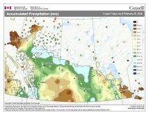
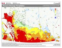
This issue’s map shows the total amount of precipitation that fell across the Prairies during the 30 days ending Nov. 25. It has been very dry across pretty much all agricultural Manitoba along with southeastern Saskatchewan.


