In my January weather review, I said 2024 might be a wild year after the rollercoaster ride of January. Well, the wild weather continued, with spring-like temperatures into February and a cold and snowy end to the month.
As we head into March, I wonder if we will see another flip like we saw last June and July, when June was more like July and July was more like June. Will March end more like a typical February or will the warm weather move back, bringing an early end to winter?
Looking at February weather across the Prairies, temperatures ranged from above average in Alberta, well above average in Saskatchewan and ridiculously above average in Manitoba.
Read Also
VIDEO: What climate change data gets wrong about the Prairies
Precipitation, not temperature, may be a better gauge of climate change impact on the Prairies, says director of the Prairie Adaptation Research Collaborative.
In February, Manitoba generally sees the coldest average temperatures of all major reporting stations, ranging from -12.5 to -13.5 C. Both Brandon and Dauphin reported mean monthly temperatures of around -7.5 C, which is five or six degrees warmer than average.
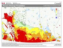
Winnipeg was the Manitoba hot spot, with a mean monthly temperature around -6 C, which was a good 7 C warmer than average. You have to go back to 1999 to find a similar February. Precipitation across this region varied from well below average in the Dauphin region, a little below average in Winnipeg and near average in Brandon. Average precipitation in February is around 13 mm.
Above-average temperatures continued in Saskatchewan, but not to the same degree. Regina saw a mean monthly temperature of around -7.6 C, about 4 C warmer than average. Farther north, Saskatoon reported a mean monthly temperature of -8.9 C, around 3.5 C warmer than average.
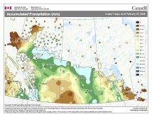
February in Saskatchewan, on average, is a very dry month with only nine mm of precipitation. This February was a little wetter than average, with Regina reporting 15.5 mm and Saskatoon around 12 mm.
In Alberta, temperatures were mild, but not as mild compared to average as they were in Saskatchewan and Manitoba. Calgary reported a mean monthly temperature of -4 C, which was about 1.5 C warmer than average.
In Edmonton, the mean monthly temperature was about -7 C, using the airport’s reading rather than the Blatchford site, which I think gives anomalously high readings. It is also hard to do comparisons using the Blatchford site, as the long-term records for Edmonton are from the airport. That -7 C reading was about 3 C warmer than average.
Moving north, Peace River saw a mean monthly temperature of -8.2 C, which was about 3.7 C warmer than average. Precipitation across southern and central regions was above average, with Calgary reporting 16.6 mm, which is about seven mm more than average.
Edmonton was the wet spot with 21.1 mm, or about nine mm greater than average. Peace River had only 3.7 mm of precipitation reported, well below the average of 14.
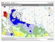
Overall, February was a very warm month across the Prairies, with eastern regions the warmest compared to average. Precipitation is a little tougher to summarize, with parts of Manitoba seeing below average, Saskatchewan slightly above average, and the southern and central parts of Alberta also above average.
I guess it would be an above-average month, precipitation-wise. But February is such a dry month that even above-average precipitation doesn’t really make a dent in the dry conditions most regions have been experiencing.
Looking back at the forecasts for February, the winner for accuracy is the computer models. They all predicted warmer-than-average temperatures with near-average precipitation. If we want to get picky, CFS and CanSIPS predicted the eastern Prairies would be warmest.
By the way, both almanacs called for well below average temperatures.
Let’s look at the latest predictions for the next few months. The Canadian Farmer’s Almanac calls for a cold and wet start to spring as it mentions, cold, very cold and chilly temperatures several times, along with stormy conditions. The Old Farmer’s Almanac is also calling for much colder than average temperatures in March and April, along with above-average precipitation.
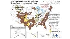
What about the weather models? I have to extrapolate the U.S. NOAA forecast northward into Canada. It calls for above-average temperatures over the next couple of months, with near-average precipitation over eastern regions and below average over far western regions.
The reliable CFS model calls for above-average temperatures in March and April, with eastern regions continuing to see the warmest temperatures compared to average. Precipitation is forecasted to be above average over eastern regions in March, with near- to slightly below-average amounts over central and western regions.
Eastern regions are forecasted to see below-average precipitation in April, with near average in central regions and above average over southern Alberta.
The Canadian CanSIPS model is singing a slightly different tune, with slightly above-average temperatures across eastern regions in March, and central and western regions seeing near- to below-average temperatures. The model then shows above-average temperatures right across the Prairies in April.
Its precipitation forecast is calling for above-average amounts over eastern regions in March, with near-average amounts over central and western regions. April is forecasted to see near-average amounts across the Prairies.
Our last weather model to look at is the ECMWF, or European model. It is forecasting a greater than 70 per cent chance of above-average temperatures across the Prairies in March and April, along with near-average precipitation.


