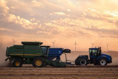
CNS Canada — The dry, balmy weather that gave farmers in Western Canada the chance to get the remainder of this year’s crop off appears to be winding down.
“There is a little disturbance in Alberta coming across to northern Saskatchewan over the next two days; it will start tonight,” said Drew Lerner of World Weather Inc. at Kansas City in an interview Tuesday morning.
The snow will likely total between two and eight cm in various regions, he added. Some of it may drift down to central Saskatchewan as well.
Read Also
Prairie forecast: Warm start then cooler air to move back in
While spring appears to be gaining a foothold across the western Prairies, it continues to struggle across the eastern regions. This forecast period looks milder than the last, but weather models are still not showing a clear or sustained shift toward a more spring-like pattern.
“I think there will be enough snow to stop fieldwork — in the northern fringes of crop country,” he said.
The recent wave of dry weather across Western Canada gave farmers a second chance to combine crops, after wet weather in September and October led many to think crops such as canola would see much lower production than previously estimated.
Initial estimates pegged this year’s canola crop at 18 million tonnes but fall rains lowered that projection to as little as 14 million. It remains to be seen how much progress producers made during the late harvest window.
Cold temperatures will likely follow the precipitation in the affected regions, Lerner added. Harvesting will still be possible in central and southern areas, but the weather we’ve had up until now will be gone.
“I’m not convinced we’ll see warmth like this until next spring,” he said.
Saskatchewan and Manitoba won’t likely see much of a threat of snow over the next seven to 10 days.
“They will probably be OK until the next storm system comes along and that’s going to be a little while,” he added.
The one variable Lerner is watching, however, is a storm down in the U.S. northern Plains. That system currently appears to be headed to southern Ontario but could strike Manitoba if it “lifts further to the north.”
— Dave Sims writes for Commodity News Service Canada, a Winnipeg company specializing in grain and commodity market reporting.