It seems you can’t listen to a conversation lately that doesn’t at some point move to the topic of spring flooding. The latest flood forecast for southern Manitoba indicates a high potential for flooding in pretty much all regions. If we continue to have favourable weather, which means little to no snow or rain over the next month, then flooding will be minimal. With average weather, flooding is expected to cause some significant issues, but with the upgrades done over the last few years, most areas will be able to pull through. The real worry is what will happen if we have unfavourable weather over the next month or so.
Read Also

June brings drought relief to western Prairies
Farmers on the Canadian Prairies saw more rain in June than they did earlier in the 2025 growing season
The problem we face in regard to spring flooding started nearly a year ago. During the spring and summer of 2010 a large portion of southern and central Manitoba experienced well-above- average rainfalls. These rainfalls saturated the soil and filled most water storage areas to near capacity. If we look at the map of groundwater content in the first two metres of soil, we see all areas have between 40 and 50 centimetres of water. With all this water on the surface and in the ground, stream and river flows going into the winter were also higher than average. This means any snow we received over the winter has no place to go. Basically then, before the winter even started, the potential for spring flooding was higher than average.
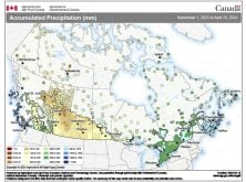
Going into winter the dice were already stacked against us. What we needed was little snow and plenty of warm weather and everything would be OK, but that’s not what happened. Instead, we experienced an average winter across all regions. Plenty of cold weather allowed the already wet ground to freeze fairly deeply, and plenty of snow fell everywhere. By the time March rolled around, the amount of water in the snowpack was quite high. If you look at the map showing water equivalent of the snowpack, as of March 12 you can see the whole region in and around southern Manitoba has a lot of water! Most regions have at least 50 millimetres of water, with some areas having upwards of 150 mm. While these amounts are not in any way record setting, they are widespread, which means overall, there is a lot of water that will be released once the melt begins, and most of it will have nowhere to go but to the rivers.
Most of us know we can have the worst winter weather and conditions leading into spring can be really bad, but that doesn’t necessarily result in spring flooding. What’s of utmost importance is what kind of weather we’ll have over the next month. Already things are not looking that great. With a cold start to the month we have not seen any real melting occur. The longer this cold weather lasts, the better the chance we’ll see a quick melt, something we don’t want. Also, over the next six weeks or so is when we historically see the heaviest snowstorms. The latest medium-range forecast models show a fairly active weather pattern between now and the end of the month, which means there will be at least a couple of good chances of seeing more precipitation – possibly lots of it.
Will this be the spring where we experience record flooding? I hope not, but I have to admit things are not looking all that great. Besides getting as prepared as possible for the flooding, we just have to cross our fingers and hope that we can continue to dodge the storms so dry weather prevails.