Believe it or not, but last week s forecast came out pretty close to what the weather models had predicted. The one main difference was the strength and size of the low that moved up from the south and ended up parking itself over Hudson Bay last weekend. This low, at its peak last Sunday, stretched from just south of the Canadian border all the way up to the top of Hudson Bay. With our region being on the back side of the low we ended up with strong northwesterly winds, which brought slightly colder temperatures than expected.
Read Also
Prairie weather all starts with the sun
The sun’s radiation comes to us in many forms, some of which are harmful to organic life while others are completely harmless or even essential, Daniel Bezte writes.
This low will finally move off by the middle of this week, which will then allow for a ridge of high pressure to build in from the south. At the same time, an area of low pressure will be tracking across the northern Prairies. While the ridge will keep southern and central regions dry during the second half of this week, the low will keep the ridge from building too far north, keeping the really mild air well to our south. We should still see a fair bit of sunshine, along with high temperatures in the low teens and overnight lows around the freezing mark.
Late next weekend and into the early part of next week, a weak area of low pressure is forecasted to move through, bringing clouds and a few showers. The models then lean toward a ridge of high pressure trying to build northward once again. This general pattern currently looks like it will last right through to the end of the month, so we should expect fairly dry conditions to continue, along with temperatures near or slightly above average.
Usual temperature range for this period:
Highs: 4 to 15 C. Lows: -6 to 4 C.
Probability of precipitation falling as snow: 40 per cent.
———
WEATHER MAP -WESTERN CANADA
Copyright 2011 Agriculture &Agri-Food Canada
3 Month (90 Days) Percent of Average Precipitation (Prairie Region)
July 16, 2011 to October 13, 2011
Prepared by Agriculture and Agri-Food Canada s National Agroclimate Information Service (NAIS). Data provided through partnership with Environment Canada, Natural Resources Canada, and many Provincial agencies.
< 40%
40 -60% 60 -85% 85 -115% 115 -150% 150 -200%
200% Extent of Agricultural Land Lakes and Rivers
Produced using near real-time data that has undergone initial quality control. The map may not be accurate for all regions due to data availability and data errors.
Created: 10/14/11
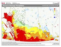
This issue s map shows the amount of precipitation that has fallen across the Prairies over the last 90 days, which comes close to covering the summer months and this fall. From the map you can see that much of agricultural Manitoba and northwestern agricultural Alberta saw fairly dry conditions during this period, both reporting at least less than 85 per cent of average precipitation. A good portion of these areas were even drier, with less than 60 per cent. A few areas were extremely dry (red) with less than 40 per cent of average amounts of precipitation recorded. Saskatchewan, northwestern Manitoba and a small area of southern Alberta were the only wet spots, with several areas reporting between 115 and 150 per cent of average.


