MANITOBA The Pas 42 cm Russell 30-35 cm Flin Flon 30 cm McCreary 30 cm Dauphin 25 cm Winnipeg 20 cm PortagelaPrairie 19cm Steinbach 15-20 cm
Emerson Brandon 16 cm 15 cm
The weather page is prepared by Daniel Bezte. Dan has a BA Honours degree in geography, specializing in climatology, from the U of W. He has taught climate and weather classes at the U of W, and is a guest climate expert on CJOB’s morning show with Larry Updike. Daniel runs a computerized weather station on his 10 acres near Birds Hill Park, which he plans to develop into a small vegetable and fruit hobby farm.
Read Also

June brings drought relief to western Prairies
Farmers on the Canadian Prairies saw more rain in June than they did earlier in the 2025 growing season
Daniel welcomes questions and comments at [email protected]
I’m not sure what I should write about this week. I promised I would talk about last week’s big storm, but I hate taking a break from our Arctic ice series, plus, it is the end of the month, so we should be doing our month review of the weather and our look ahead. After weighing everything out I figured we should look back at the big storm and take a look at just how big and bad this storm really was. Next week we’ll look ahead at what February and March weather has in store for us. Then we’ll finish our look at Arctic sea ice. Now…on to last week’s storm!
Depending where you live, this storm was anywhere from just average to one of the biggest storms in a long time.
As my students in Grade 9 would say, this storm system was truly epic in its size, strength, and overall geographic coverage. It developed over the Pacific and finally came ashore along the west coast of the United States Jan. 21. During El Nińo years, strong storm systems will often affect this part of North America, but this system was particularly strong.
In fact, it was reported that it was the most powerful low-pressure system in 140 years of record keeping in this region. The storm set all-time low-pressure records over roughly 10 to 15 per cent of the U. S. – over southern California, Nevada, Arizona, and Utah.
In California, there was record rain and snowfall, high winds, and even several tornadoes. Tornadoes in California are fairly rare and even more so in January. But to have five possible tornadoes is truly amazing! The highest snowfall reported in California was 185 cm and the greatest rainfall total reported was 370 mm in Los Gatos.
This heavy snow and rain also occurred in Nevada, Arizona, New Mexico, Utah, and Colorado. In Arizona, one possible tornado was reported, along with extremely high winds as a strong cold front pushed through. Apache Junction, Arizona reported sustained winds of 120 km/h with gusts to 150 which is hurricane strength.
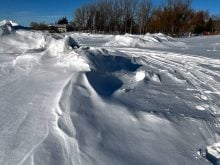
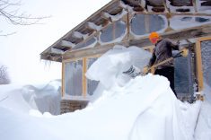
The storm system then pushed into our region bringing ice pellets and wet snow to southern regions of Manitoba, before changing over to just good old snow and blowing snow on Monday. Farther north and into central Saskatchewan heavy snow was reported. The following table has some of the snowfall totals from Manitoba and Saskatchewan.
While we were getting hit with high winds and blizzard conditions on Monday, the storm spread eastward bringing record rainfalls to parts of Ontario and Quebec, along with the northeastern U. S. So, when you add it all up, this storm affected, in one way or another, an absolutely huge portion of central North America. If someone were to calculate just how much precipitation this storm produced I think the numbers would be absolutely astounding. I took a shot at it and came up with an amazing amount of 25 billion cubic metres of water (12.5 mm of precipitation over about two million square km of land).
When we get right down to it, it was all the warm air with this storm that prevented it from becoming a truly monstrous storm for our region. Mother Nature had all the ingredients ready to really cook up a huge winter storm. There was plenty of warm, moist air, a large deep area of low pressure, slow movement of the low, and cold air ready to move in. The problem (or good thing – depending on what you wanted to happen) was that she didn’t add the ingredients at the right time or in the right amounts.
To begin with, Mother Nature added too much warm air into the mix. This warm air pushed strongly north bringing mild melting temperatures to southern Manitoba, causing the precipitation to be wet and greatly reducing snowfall accumulations. Farther north, this warm air wasn’t able to push out the cold air, so instead it rode up and over the cold air and the precipitation fell as snow – lots of snow. The second ingredient that got messed up was the cold air. Just like with the warm, moist air, there was a good shot of cold air waiting to move into this system, but for most of Manitoba it was added into the recipe just a little too late.
We saw the cold air really start pouring in late on Sunday and throughout the day on Monday which coincided with the worst part of the storm. If that cold air had worked into the system a day earlier we really would have been socked in come Monday.
Will we see another big storm this winter, or was this our one and only shot? You just never know. With the pattern looking to stay the same for the next few months Mother Nature just might be able to put all the ingredients together one more time!