The blocking ridge of high pressure that brought sunny skies and warm temperatures last week has moved to the east and a large trough of low pressure has taken its place over our region.
With high pressure to our east and low pressure to our west, the general flow of the atmosphere over our region is from the south or southwest. This flow is allowing for plenty of moisture from the Gulf of Mexico to stream north, fuelling thunderstorms and areas of low pressure spinning off the main trough.
Read Also

Thunderstorms and straight-line winds
Straight-line winds in thunderstorms can cause as much damage as a tornado and are next on our weather school list exploring how and why severe summer weather forms.
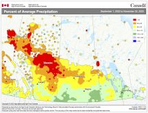
It also makes for a tough forecast, as most of these storm systems are driven by convection and exactly where the main area of convection will take place is always tough to figure out. Saskatchewan continues to look like it will be the wettest during this forecast period while in Alberta, it should be drier but on the cool side.
Over Manitoba, things will be a little trickier to forecast as we will be in the mildest air, relatively speaking, and subject to convective precipitation.
During the middle of the week we should see a break in the weather as weak high pressure builds in, but by the end of the week another area of low pressure will develop in the western trough and we will likely see more rain in Saskatchewan and thunderstorms over Manitoba.
Temperatures will be a little tricky; it looks as if there will be a fairly strong temperature contrast from north to south over our region. Highs over southern regions could warm into the upper 20s, but over central regions they look to struggle to hit 20 C.
This general pattern looks as if it will continue into next week. Usual temperature range for this period: Highs: 16 to 27 C. Lows: 3 to 12 C.


