First off, I have to apologize for missing last week. No excuses, I simply screwed up and missed my deadline. So, for this week’s article, I am going to do my best to combine the key parts of last week’s article with the new stuff from this week.
Since it is the end of the month, or rather the start of a new month, that means it is time for our monthly look back and then our look ahead. In the last issue I was supposed to take a look at what kind of winters we have seen after experiencing a snowy or wet fall, so I will combine that outlook with the latest long-term outlooks issued by the different forecasters.
Read Also
Manitoba winter 2025-26 outstays its welcome
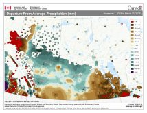
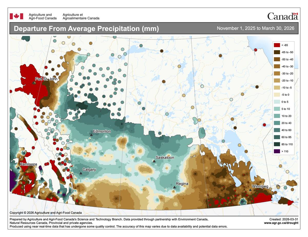
March ran 2 to 3 C below average across central Saskatchewan and southern Manitoba, capping a winter that was drier than normal nearly everywhere but Calgary.
It doesn’t take a weather genius to know that October 2019 was colder and wetter than average. The question is, just how much colder and wetter was it?
 Looking at the data from the three main locations across agricultural Manitoba (Winnipeg, Brandon and Dauphin) it turns out that all three stations reported a mean monthly temperature for October that ranged from 1.5 C below average in Winnipeg and Brandon, to 2.0 C below average in Dauphin.
Looking at precipitation during the month, both the Winnipeg and Brandon regions reported above-average precipitation. Winnipeg was only slightly above average, with a total of 40.5 mm, which is only about five mm above its average. Brandon was a little wetter, with a total of 50 mm, which was nearly 20 mm above its long-term average. Of course, for some sites it was even wetter, with some areas seeing upwards of 75 to 100 mm during the month. The driest region was in the northwest, where Dauphin reported 34 mm, which was a couple of millimetres below average.
Looking back at the different predictions for October it looks like we have three winners. The Canadian Farmers’ Almanac, NOAA, and the CFS weather model all called for near- to below-average temperatures along with above-average amounts of precipitation. I don’t remember the last time three different forecasts got it right!
Now it is time to look ahead to what November and December might have in store for us. Starting with the almanacs, the Old Farmer’s Almanac is calling for a warm and dry November, followed by a really warm and slightly wetter-than-average December. The Canadian Farmers’ Almanac looks to be calling for colder-than-average temperatures along with above-average precipitation in both November and December as it mentions cold periods, frigid temperatures, along with snow, rain, and general storminess several times each month.
Now on to the computer weather models. NOAA is calling for below-average temperatures in November, transitioning to near average in December, along with near-average precipitation in both months. The CFS model is calling for below-average temperatures in November, but above to well above average in December. Precipitation is forecasted to be near to slightly above average in November and near average in December. Moving on to the CanSIPS model, it is pretty much mimicking the CFS model, with a cold November followed by a warm December and near-average precipitation, with the chance of above-average amounts in November.
Lastly, there is my forecast. I am following the majority of the forecasts with a call for a colder-than-average November along with near-average precipitation. December will follow up with above-average temperatures and I am also leaning toward above-average amounts of precipitation.
Now, before wrapping up this issue I promised I would look back at what kind of winters have we seen when it has been a wet fall or a snowy October? To answer this I only used Winnipeg’s data simply because it has the longest continuous record and winter conditions across southern and central Manitoba tend to be fairly uniform.
I looked back at all the years that met these criteria and then looked at the average winter temperature and total snowfall for those years, and here’s how those winters turned out.
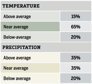
Looking at this data the highest probability is near-average temperatures with near- to above-average amounts of precipitation. I did notice as I went quickly through each year’s data, that a number of the winters saw big swings between warm and cold months and wet and dry months.
So, while the winter as a whole may have been average, some of the months in those winters were very wintery, with a lot of snow and other months were nice and dry. With the current long-range weather models continuing to show cool weather continuing into November, it will be interesting to see if this up-and-down winter pattern develops this year.