Another month has come and gone, and nearly another school year.
As a Grade 7 student nicely pointed out to me today, the older you get the fast time seems to travel. Thanks for the reminder, I guess.
As we wrap up the last month of meteorological spring and start the first month of summer, it is time for our monthly look at how the weather behaved last month, compare it to what the weather models predicted, and then look ahead to see if there are any changes to the long-range forecast for the rest of the summer.
Read Also

Forecasting spring 2026 weather on the Prairies
What weather can farmers expect across Manitoba, Alberta and Saskatchewan as they head into seeding? Plus: a lesson on what makes the seasons turn
I don’t know about you, but I am sure hoping that there is a shift towards a wetter summer.
As usual, I am going to stick with the format I have been using now for a while and that is, we will look at the average temperature rankings for the main reporting centers in each province, followed by a look at how those actual temperatures compare to average. We will then follow that up with a look at precipitation rankings and how they compare to average.
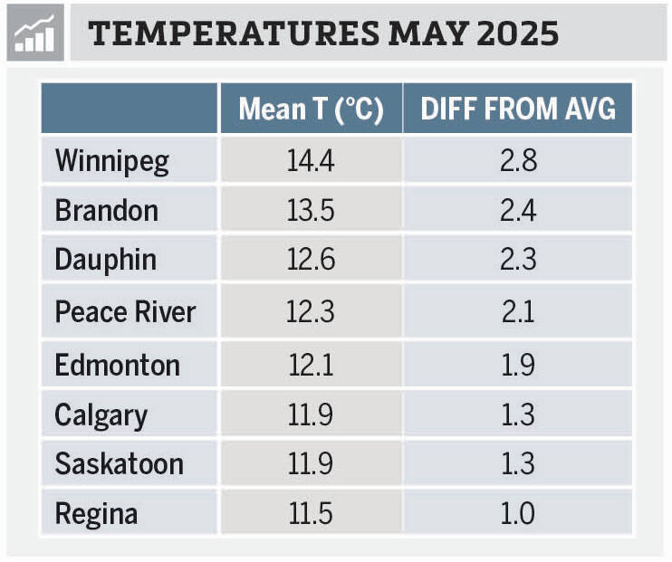
Looking at May’s temperatures, you can see that all of our stations reported above-average temperatures in May. In fact, five of the eight stations reported mean monthly temperatures that were greater than 1.5 degrees Celsius above the long-term average, with half reporting temperatures greater than 2.0 C above the long-term average.
The warmest location both in actual temperature and compared to average was Winnipeg. The cold spot was also in Manitoba with Dauphin reporting both the coldest actual temperature and the least above average temperature. Record setting heat early in the month contributed to Winnipeg’s numbers, while the western part of Manitoba saw plenty of clouds and showers earlier in the month which helped to keep temperatures down.
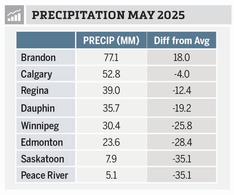
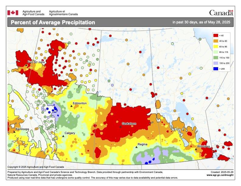
Looking at precipitation, the numbers tell a story of just how dry some regions have been.
May was once again a dry month right across the Prairies with the one exception — Brandon, Man. If you look at the map of precipitation compared to average for May you can see that southwestern Manitoba and southeastern Saskatchewan, along with west-central Alberta, were the only regions to report above average precipitation. Brandon was the only major reporting center in those above average areas.
What really stands out is just how dry Saskatoon and Peace River were in May. Looking back at both locations, Saskatoon has only recorded 36 mm of water equivalent precipitation so far this year, while Peace River is at a paltry 26 mm. Digging a little deeper into the precipitation deficits so far this year, both Winnipeg and Peace River are both running a deficit of about 83 mm.
Overall, it was also a warmer-than-average May right across the Prairies, with the region arcing from southeastern Manitoba, across central Saskatchewan, and into central and southern Alberta seeing warmest conditions. Overall precipitation was below to much below-average with a few locations seeing near to above average.
If we look back at the forecasts for the month, the almanacs were well off with their forecasts of near average temperatures and above average precipitation. As for the winner, it would appear to be a tie between last month’s winner, the CanSIPS model, the American CFS, and the European ECMWF. All of them called for above-average temperatures with near to below-average precipitation. I’ll let you look back and see which one you think squeaked out the win.
Now on to the latest and greatest summer forecasts, starting off as usual with our two almanacs. The Old Farmers Almanac is calling for slightly above-average temperatures in June followed by near-average temperatures in July and below-average in August. Their precipitation forecast is calling for near-average amounts in June and above-average in July and August. The Canadian Farmers Almanac, after reading between the lines, appears to be calling for near- to above-average temperatures and precipitation in June. Their July forecast seems to be leaning towards a hot and dry July because they mention hot and dry a few times. The last month of the summer, according to them, will see near- to above-average temperatures with near average precipitation.
Moving on to the different weather models. NOAA’s forecast, extrapolating northwards, looks to be calling for slightly above-average temperature across the eastern Prairies this summer with the western Prairies seeing above-average to well above-average temperatures from June right through to August.
NOAA’s precipitation forecast is still calling for below average amounts all summer long with the driest conditions expected to be across Alberta.
Looking at the CFS model, it has changed its tune a little bit. The June forecast is for above average temperatures across the eastern half of the Prairies with near average temperatures across the western half. July and August are forecast to see near to slightly above-average temperatures, with the northern regions seeing the best chance of having above-average temperatures. Their precipitation forecast is now calling for above-average precipitation across southern Manitoba all summer long with north-central Saskatchewan and central Alberta also seeing above-average amounts in July and August. The rest of the Prairies are forecast to see near to below average amounts, with southern Alberta expected to be the driest. The CanSIPS model wasn’t updated in time for this column, unfortunately.
Last on our list of computer models is the ECMWF which predicts well above-average temperatures in June and July with slightly cooler but still above-average temperatures in August. Their precipitation forecast is calling for most regions to experience below-average amounts in June and July with August coming in near-average.
I am going with climatology on this one. With global temperatures this year expected to be in the top five all-time hottest, the odds are in our favour that we will see a warmer-than-average summer. Usually when we have a hot summer, we see below-average precipitation.
The wild card this summer is — smoke. In the next issue we will re-examine the impact that widespread smoke can have on our weather.